Kunigal geodata
Kunigal (Karnataka) is a populated place; located in India in Asia/Kolkata (GMT+5.5) time zone. With population of 33,273 people, there are 1308 cities with bigger population in this country. Compared to other cities in India, 86.2% of cities are located further ↑North; 62.9% of cities are located further →East and 93.6% of cities have lower elevation than Kunigal. Note1


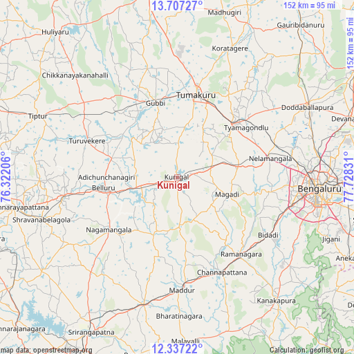
Kunigal GPS coordinates[2]
13° 1' 23.484" North, 77° 1' 30.648" East
| Map corner | latitude | longitude |
|---|---|---|
| Upper-left | 13.70727°, | 76.32206° |
| Center: | 13.02319°, | 77.02518° |
| Lower-right: | 12.33722°, | 77.72831° |
| Map W x H: | 152.3×152.3 km | = 94.6×94.6mi |
| max Lat: | 34.9274° ⇑86.2% North |
| Kunigal: | 13.02319° |
| min Lat: | ⇓13.8% South 8.09008° |
| min Long | Kunigal | max Long |
| 68.82655° | 77.02518° | 96.81° |
| W 37.1%⇐ | ⇒62.9% E |
Elevation
Elevation of Kunigal is 778 m = 2552 ft, and this is 482.4 m = 1583 ft above average elevation for this country.
| Max E: |
3681 m = 12077 ft | 6.4% |
| Kunigal | 778 m 2552 ft | |
| Avg. | 295.6 m = 970 ft | |
Min E: |
1 m = 3 ft | 93.6% |
See also: India elevation on elevation.city.
Geographical zone
Kunigal is located in North Torrid zone (between Equator and Tropic of Cancer). Distance of this Northern Tropic circle is 1157.9 km =719.5 mi to North.| Distance of | km | miles | from Kunigal |
|---|---|---|---|
| North Pole | 8559 | 5318.3 | to North |
| Arctic Circle | 5953.1 | 3699.1 | to North |
| Tropic Cancer | 1157.9 | 719.5 | to North |
| Equator | 1448 | 899.7 | to South |


Nearby cities:
15 places around Kunigal: (largest is in red/bold)
• Bellūru
32 km =19.9 mi,  261°
261°
• Bengaluru
61.9 km =38.5 mi,  95°
95°
• Channapatna
45.8 km =28.5 mi,  154°
154°
• Closepet
43.5 km =27 mi,  140°
140°
• Gubbi
33.4 km =20.8 mi,  344°
344°
• Koratagere
60 km =37.3 mi,  22°
22°
• Maddūr
49 km =30.4 mi,  177°
177°
• Mandya
57.4 km =35.7 mi,  193°
193°
• Melukote
57.2 km =35.5 mi,  225°
225°
• Māgadi
22.7 km =14.1 mi,  108°
108°
• Nelamangala
40.8 km =25.4 mi,  77°
77°
• Nāgamangala
37.1 km =23.1 mi, 232°
• Srāvana Belgola
61 km =37.9 mi,  252°
252°
• Tumkūr
36.3 km =22.6 mi,  13°
13°
• Turuvekere
41.9 km =26 mi,  291°
291°
Sources, notices
• [Note1] Compared only with cities in India existing in our database
• [Src1] Map data: © OpenStreetMap contributors (CC-BY-SA)
• [Src2] Other city data from geonames.org with taken over terms of usage.
• [Src3] Geographical zone / Annual Mean Temperature by Robert A. Rohde @ Wikipedia
