Anekal geodata
Anekal (Karnataka) is a populated place; located in India in Asia/Kolkata (GMT+5.5) time zone. With population of 36,693 people, there are 1196 cities with bigger population in this country. Compared to other cities in India, 87.8% of cities are located further ↑North; 55.1% of cities are located further →East and 95.6% of cities have lower elevation than Anekal. Note1


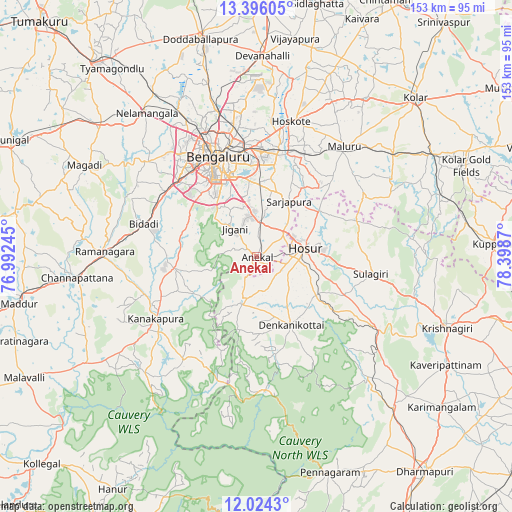
Anekal GPS coordinates[2]
12° 42' 39.96" North, 77° 41' 44.052" East
| Map corner | latitude | longitude |
|---|---|---|
| Upper-left | 13.39605°, | 76.99245° |
| Center: | 12.7111°, | 77.69557° |
| Lower-right: | 12.0243°, | 78.3987° |
| Map W x H: | 152.5×152.5 km | = 94.8×94.8mi |
| max Lat: | 34.9274° ⇑87.8% North |
| Anekal: | 12.7111° |
| min Lat: | ⇓12.2% South 8.09008° |
| min Long | Anekal | max Long |
| 68.82655° | 77.69557° | 96.81° |
| W 44.9%⇐ | ⇒55.1% E |
Elevation
Elevation of Anekal is 927 m = 3041 ft, and this is 631.4 m = 2072 ft above average elevation for this country.
| Max E: |
3681 m = 12077 ft | 4.4% |
| Anekal | 927 m 3041 ft | |
| Avg. | 295.6 m = 970 ft | |
Min E: |
1 m = 3 ft | 95.6% |
See also: India elevation on elevation.city.
Geographical zone
Anekal is located in North Torrid zone (between Equator and Tropic of Cancer). Distance of this Northern Tropic circle is 1192.6 km =741 mi to North.| Distance of | km | miles | from Anekal |
|---|---|---|---|
| North Pole | 8593.7 | 5339.9 | to North |
| Arctic Circle | 5987.8 | 3720.6 | to North |
| Tropic Cancer | 1192.6 | 741 | to North |
| Equator | 1413.3 | 878.2 | to South |


Nearby cities:
15 places around Anekal: (largest is in red/bold)
• Bengaluru
31 km =19.3 mi,  339°
339°
• Channapatna
53.4 km =33.2 mi,  262°
262°
• Closepet
44.9 km =27.9 mi,  271°
271°
• Dasarahalli
45.6 km =28.3 mi,  18°
18°
• Denkanikota
22.5 km =14 mi,  153°
153°
• Devanhalli
59.6 km =37 mi,  1°
1°
• Hoskote
41.5 km =25.8 mi, 15°
• Hosūr
15.1 km =9.4 mi,  79°
79°
• Kelamangalam
20.8 km =12.9 mi,  125°
125°
• Kānkānhalli
35 km =21.7 mi,  238°
238°
• Māgadi
58 km =36 mi,  298°
298°
• Mālūr
41.8 km =26 mi,  38°
38°
• Mārāndahalli
49 km =30.4 mi,  137°
137°
• Nelamangala
54.2 km =33.7 mi,  322°
322°
• Yelahanka
44.6 km =27.7 mi,  346°
346°
Sources, notices
• [Note1] Compared only with cities in India existing in our database
• [Src1] Map data: © OpenStreetMap contributors (CC-BY-SA)
• [Src2] Other city data from geonames.org with taken over terms of usage.
• [Src3] Geographical zone / Annual Mean Temperature by Robert A. Rohde @ Wikipedia
