Māgadi geodata
Māgadi (Karnataka) is a populated place; located in India in Asia/Kolkata (GMT+5.5) time zone. With population of 27,213 people, there are 1576 cities with bigger population in this country. Compared to other cities in India, 86.7% of cities are located further ↑North; 60.9% of cities are located further →East and 95% of cities have lower elevation than Māgadi. Note1


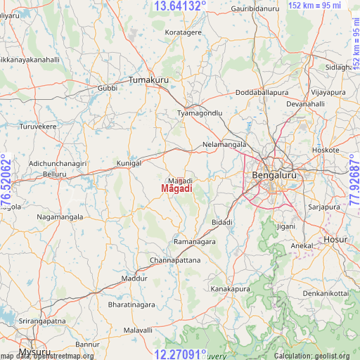
Māgadi GPS coordinates[2]
12° 57' 25.416" North, 77° 13' 25.464" East
| Map corner | latitude | longitude |
|---|---|---|
| Upper-left | 13.64132°, | 76.52062° |
| Center: | 12.95706°, | 77.22374° |
| Lower-right: | 12.27091°, | 77.92687° |
| Map W x H: | 152.4×152.4 km | = 94.7×94.7mi |
| max Lat: | 34.9274° ⇑86.7% North |
| Māgadi: | 12.95706° |
| min Lat: | ⇓13.3% South 8.09008° |
| min Long | Māgadi | max Long |
| 68.82655° | 77.22374° | 96.81° |
| W 39.1%⇐ | ⇒60.9% E |
Elevation
Elevation of Māgadi is 879 m = 2884 ft, and this is 583.4 m = 1914 ft above average elevation for this country.
| Max E: |
3681 m = 12077 ft | 5% |
| Māgadi | 879 m 2884 ft | |
| Avg. | 295.6 m = 970 ft | |
Min E: |
1 m = 3 ft | 95% |
See also: India elevation on elevation.city.
Geographical zone
Māgadi is located in North Torrid zone (between Equator and Tropic of Cancer). Distance of this Northern Tropic circle is 1165.2 km =724 mi to North.| Distance of | km | miles | from Māgadi |
|---|---|---|---|
| North Pole | 8566.4 | 5322.9 | to North |
| Arctic Circle | 5960.5 | 3703.7 | to North |
| Tropic Cancer | 1165.2 | 724 | to North |
| Equator | 1440.7 | 895.2 | to South |


Nearby cities:
15 places around Māgadi: (largest is in red/bold)
• Anekal
58 km =36 mi,  118°
118°
• Bellūru
53.2 km =33.1 mi,  272°
272°
• Bengaluru
40.1 km =24.9 mi,  87°
87°
• Channapatna
34 km =21.1 mi,  183°
183°
• Closepet
26.9 km =16.7 mi,  166°
166°
• Dod Ballāpur
50.6 km =31.4 mi,  42°
42°
• Gubbi
50 km =31.1 mi,  322°
322°
• Kunigal
22.7 km =14.1 mi,  288°
288°
• Kānkānhalli
50.4 km =31.3 mi,  154°
154°
• Maddūr
46 km =28.6 mi,  205°
205°
• Mandya
59.9 km =37.2 mi,  216°
216°
• Nelamangala
24.3 km =15.1 mi,  49°
49°
• Nāgamangala
53.1 km =33 mi,  253°
253°
• Tumkūr
44.7 km =27.8 mi,  342°
342°
• Yelahanka
43.4 km =27 mi,  68°
68°
Sources, notices
• [Note1] Compared only with cities in India existing in our database
• [Src1] Map data: © OpenStreetMap contributors (CC-BY-SA)
• [Src2] Other city data from geonames.org with taken over terms of usage.
• [Src3] Geographical zone / Annual Mean Temperature by Robert A. Rohde @ Wikipedia
