Channapatna geodata
Channapatna (Karnataka) is a populated place; located in India in Asia/Kolkata (GMT+5.5) time zone. With population of 66,647 people, there are 651 cities with bigger population in this country. Compared to other cities in India, 88% of cities are located further ↑North; 60.9% of cities are located further →East and 91.5% of cities have lower elevation than Channapatna. Note1


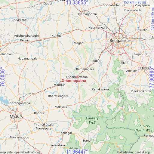
Channapatna GPS coordinates[2]
12° 39' 5.148" North, 77° 12' 24.192" East
| Map corner | latitude | longitude |
|---|---|---|
| Upper-left | 13.33655°, | 76.5036° |
| Center: | 12.65143°, | 77.20672° |
| Lower-right: | 11.96447°, | 77.90985° |
| Map W x H: | 152.6×152.6 km | = 94.8×94.8mi |
| max Lat: | 34.9274° ⇑88% North |
| Channapatna: | 12.65143° |
| min Lat: | ⇓12% South 8.09008° |
| min Long | Channapatna | max Long |
| 68.82655° | 77.20672° | 96.81° |
| W 39.1%⇐ | ⇒60.9% E |
Elevation
Elevation of Channapatna is 669 m = 2195 ft, and this is 373.4 m = 1225 ft above average elevation for this country.
| Max E: |
3681 m = 12077 ft | 8.5% |
| Channapatna | 669 m 2195 ft | |
| Avg. | 295.6 m = 970 ft | |
Min E: |
1 m = 3 ft | 91.5% |
See also: Channapatna elevation on elevation.city.
Geographical zone
Channapatna is located in North Torrid zone (between Equator and Tropic of Cancer). Distance of this Northern Tropic circle is 1199.2 km =745.1 mi to North.| Distance of | km | miles | from Channapatna |
|---|---|---|---|
| North Pole | 8600.4 | 5344 | to North |
| Arctic Circle | 5994.5 | 3724.8 | to North |
| Tropic Cancer | 1199.2 | 745.1 | to North |
| Equator | 1406.7 | 874.1 | to South |


Nearby cities:
15 places around Channapatna: (largest is in red/bold)
• Anekal
53.4 km =33.2 mi,  82°
82°
• Bannūr
51.5 km =32 mi,  226°
226°
• Bengaluru
55 km =34.2 mi,  49°
49°
• Closepet
11.3 km =7 mi, 46°
• French Rocks
60.2 km =37.4 mi,  253°
253°
• Kollegāl
56.2 km =34.9 mi,  190°
190°
• Kunigal
45.8 km =28.5 mi,  334°
334°
• Kānkānhalli
25.9 km =16.1 mi,  116°
116°
• Maddūr
19.3 km =12 mi, 246°
• Malavalli
33.6 km =20.9 mi,  208°
208°
• Mandya
36.5 km =22.7 mi, 246°
• Māgadi
34 km =21.1 mi,  3°
3°
• Nelamangala
53.8 km =33.4 mi,  22°
22°
• Nāgamangala
52.5 km =32.6 mi,  290°
290°
• Tirumakūdal Narsipur
59 km =36.7 mi, 214°
Sources, notices
• [Note1] Compared only with cities in India existing in our database
• [Src1] Map data: © OpenStreetMap contributors (CC-BY-SA)
• [Src2] Other city data from geonames.org with taken over terms of usage.
• [Src3] Geographical zone / Annual Mean Temperature by Robert A. Rohde @ Wikipedia
