Closepet geodata
Closepet (Karnataka) is a populated place; located in India in Asia/Kolkata (GMT+5.5) time zone. With population of 93,528 people, there are 478 cities with bigger population in this country. Compared to other cities in India, 87.7% of cities are located further ↑North; 60.2% of cities are located further →East and 92.3% of cities have lower elevation than Closepet. Note1


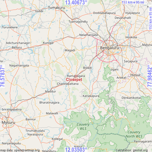
Closepet GPS coordinates[2]
12° 43' 18.516" North, 77° 16' 53.364" East
| Map corner | latitude | longitude |
|---|---|---|
| Upper-left | 13.40673°, | 76.57837° |
| Center: | 12.72181°, | 77.28149° |
| Lower-right: | 12.03503°, | 77.98462° |
| Map W x H: | 152.5×152.5 km | = 94.8×94.8mi |
| max Lat: | 34.9274° ⇑87.7% North |
| Closepet: | 12.72181° |
| min Lat: | ⇓12.3% South 8.09008° |
| min Long | Closepet | max Long |
| 68.82655° | 77.28149° | 96.81° |
| W 39.8%⇐ | ⇒60.2% E |
Elevation
Elevation of Closepet is 695 m = 2280 ft, and this is 399.4 m = 1310 ft above average elevation for this country.
| Max E: |
3681 m = 12077 ft | 7.7% |
| Closepet | 695 m 2280 ft | |
| Avg. | 295.6 m = 970 ft | |
Min E: |
1 m = 3 ft | 92.3% |
See also: Closepet elevation on elevation.city.
Geographical zone
Closepet is located in North Torrid zone (between Equator and Tropic of Cancer). Distance of this Northern Tropic circle is 1191.4 km =740.3 mi to North.| Distance of | km | miles | from Closepet |
|---|---|---|---|
| North Pole | 8592.5 | 5339.1 | to North |
| Arctic Circle | 5986.6 | 3719.9 | to North |
| Tropic Cancer | 1191.4 | 740.3 | to North |
| Equator | 1414.5 | 878.9 | to South |


Nearby cities:
15 places around Closepet: (largest is in red/bold)
• Anekal
44.9 km =27.9 mi,  91°
91°
• Bannūr
62.8 km =39 mi,  226°
226°
• Bengaluru
43.8 km =27.2 mi,  50°
50°
• Channapatna
11.3 km =7 mi, 226°
• Denkanikota
59 km =36.7 mi,  111°
111°
• Hosūr
59.8 km =37.2 mi, 88°
• Kunigal
43.5 km =27 mi,  320°
320°
• Kānkānhalli
24.6 km =15.3 mi,  142°
142°
• Maddūr
30.1 km =18.7 mi,  239°
239°
• Malavalli
44.4 km =27.6 mi,  212°
212°
• Mandya
47.2 km =29.3 mi, 241°
• Māgadi
26.9 km =16.7 mi,  346°
346°
• Nelamangala
43.7 km =27.2 mi,  16°
16°
• Nāgamangala
58.2 km =36.2 mi,  280°
280°
• Yelahanka
54.2 km =33.7 mi,  39°
39°
Sources, notices
• [Note1] Compared only with cities in India existing in our database
• [Src1] Map data: © OpenStreetMap contributors (CC-BY-SA)
• [Src2] Other city data from geonames.org with taken over terms of usage.
• [Src3] Geographical zone / Annual Mean Temperature by Robert A. Rohde @ Wikipedia
