Tiruppuvanam geodata
Tiruppuvanam (Tamil Nadu) is a populated place; located in India in Asia/Kolkata (GMT+5.5) time zone. With population of 22,517 people, there are 1875 cities with bigger population in this country. Compared to other cities in India, 97% of cities are located further ↑North; 51.8% of cities are located further ←West and 66.6% of cities have higher elevation than Tiruppuvanam. Note1


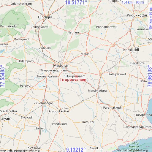
Tiruppuvanam GPS coordinates[2]
9° 49' 32.304" North, 78° 15' 28.62" East
| Map corner | latitude | longitude |
|---|---|---|
| Upper-left | 10.51771°, | 77.55483° |
| Center: | 9.82564°, | 78.25795° |
| Lower-right: | 9.13212°, | 78.96108° |
| Map W x H: | 154.1×154.1 km | = 95.8×95.8mi |
| max Lat: | 34.9274° ⇑97% North |
| Tiruppuvanam: | 9.82564° |
| min Lat: | ⇓3% South 8.09008° |
| min Long | Tiruppuvanam | max Long |
| 68.82655° | 78.25795° | 96.81° |
| W 51.8%⇐ | ⇒48.2% E |
Elevation
Elevation of Tiruppuvanam is 109 m = 358 ft, and this is 186.6 m = 612 ft below average elevation for this country.
| Max E: |
3681 m = 12077 ft | 66.6% |
| Avg. | 295.6 m = 970 ft | |
| Tiruppuvanam | 109 m = 358 ft | |
Min E: |
1 m = 3 ft | 33.4% |
See also: India elevation on elevation.city.
Geographical zone
Tiruppuvanam is located in North Torrid zone (between Equator and Tropic of Cancer). Distance of Equator is 1092.5 km =678.8 mi to South.| Distance of | km | miles | from Tiruppuvanam |
|---|---|---|---|
| North Pole | 8914.6 | 5539.3 | to North |
| Arctic Circle | 6308.7 | 3920 | to North |
| Tropic Cancer | 1513.4 | 940.4 | to North |
| Equator | 1092.5 | 678.8 | to South |


Nearby cities:
15 places around Tiruppuvanam: (largest is in red/bold)
• Alangānallūr
30.7 km =19.1 mi,  323°
323°
• Aruppukkottai
39.4 km =24.5 mi,  206°
206°
• Kallupatti
44.6 km =27.7 mi,  254°
254°
• Kariapatti
24.1 km =15 mi,  225°
225°
• Madurai
18.4 km =11.4 mi,  304°
304°
• Manamadurai
28.8 km =17.9 mi,  125°
125°
• Mangalam
42.4 km =26.3 mi,  99°
99°
• Melur
24.7 km =15.3 mi,  21°
21°
• Nattam
44.8 km =27.8 mi,  356°
356°
• Nāttarasankottai
32.7 km =20.3 mi,  81°
81°
• Pālamedu
34.9 km =21.7 mi,  332°
332°
• Sivaganga
24.8 km =15.4 mi, 84°
• Tirupparangunram
21.2 km =13.2 mi,  287°
287°
• Virudunagar
42.4 km =26.3 mi, 230°
• Vādippatti
43.4 km =27 mi,  311°
311°
Sources, notices
• [Note1] Compared only with cities in India existing in our database
• [Src1] Map data: © OpenStreetMap contributors (CC-BY-SA)
• [Src2] Other city data from geonames.org with taken over terms of usage.
• [Src3] Geographical zone / Annual Mean Temperature by Robert A. Rohde @ Wikipedia
