Nāngloi Jāt geodata
Nāngloi Jāt (Delhi) is a populated place; located in India in Asia/Kolkata (GMT+5.5) time zone. With population of 194,363 people, there are 220 cities with bigger population in this country. Compared to other cities in India, 87.7% of cities are located further ↓South; 62.3% of cities are located further →East and 53% of cities have lower elevation than Nāngloi Jāt. Note1


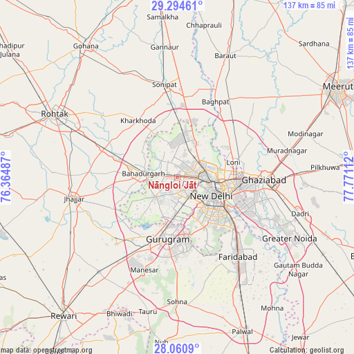
Nāngloi Jāt GPS coordinates[2]
28° 40' 46.452" North, 77° 4' 4.764" East
| Map corner | latitude | longitude |
|---|---|---|
| Upper-left | 29.29461°, | 76.36487° |
| Center: | 28.67957°, | 77.06799° |
| Lower-right: | 28.0609°, | 77.77112° |
| Map W x H: | 137.2×137.2 km | = 85.3×85.3mi |
| max Lat: | 34.9274° ⇑12.3% North |
| Nāngloi Jāt: | 28.67957° |
| min Lat: | ⇓87.7% South 8.09008° |
| min Long | Nāngloi Jāt | max Long |
| 68.82655° | 77.06799° | 96.81° |
| W 37.7%⇐ | ⇒62.3% E |
Elevation
Elevation of Nāngloi Jāt is 218 m = 715 ft, and this is 77.6 m = 255 ft below average elevation for this country.
| Max E: |
3681 m = 12077 ft | 47% |
| Avg. | 295.6 m = 970 ft | |
| Nāngloi Jāt | 218 m = 715 ft | |
Min E: |
1 m = 3 ft | 53% |
See also: Nāngloi Jāt elevation on elevation.city.
Geographical zone
Nāngloi Jāt is located in North temperate zone (between Tropic of Cancer and the Arctic Circle). Distance of this Northern Tropic circle is 583 km =362.3 mi to South.| Distance of | km | miles | from Nāngloi Jāt |
|---|---|---|---|
| North Pole | 6818.2 | 4236.6 | to North |
| Arctic Circle | 4212.3 | 2617.4 | to North |
| Tropic Cancer | 583 | 362.3 | to South |
| Equator | 3188.9 | 1981.5 | to South |


Nearby cities:
15 places around Nāngloi Jāt: (largest is in red/bold)
• Alīpur
14.7 km =9.1 mi,  25°
25°
• Bahādurgarh
13 km =8.1 mi,  276°
276°
• Bawāna
13.6 km =8.5 mi,  346°
346°
• Defence Colony
20.1 km =12.5 mi,  126°
126°
• Delhi
16.2 km =10.1 mi,  100°
100°
• Deoli
25.3 km =15.7 mi,  141°
141°
• Gurgaon
24.7 km =15.3 mi,  189°
189°
• Karol Bāgh
12.4 km =7.7 mi, 104°
• Loni
23.1 km =14.4 mi,  69°
69°
• Najafgarh
11.6 km =7.2 mi,  227°
227°
• Narela
19.4 km =12.1 mi,  7°
7°
• New Delhi
16 km =9.9 mi,  107°
107°
• Pitampura
6.3 km =3.9 mi,  79°
79°
• Rohini
7.1 km =4.4 mi,  359°
359°
• Shahdara
11 km =6.8 mi, 140°
Sources, notices
• [Note1] Compared only with cities in India existing in our database
• [Src1] Map data: © OpenStreetMap contributors (CC-BY-SA)
• [Src2] Other city data from geonames.org with taken over terms of usage.
• [Src3] Geographical zone / Annual Mean Temperature by Robert A. Rohde @ Wikipedia
