Narela geodata
Narela (Delhi) is a populated place; located in India in Asia/Kolkata (GMT+5.5) time zone. With population of 800,000 people, there are 55 cities with bigger population in this country. Compared to other cities in India, 88.5% of cities are located further ↓South; 62.1% of cities are located further →East and 53.3% of cities have lower elevation than Narela. Note1


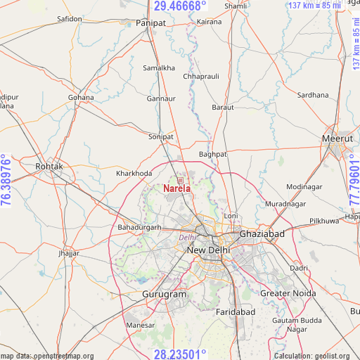
Narela GPS coordinates[2]
28° 51' 9.612" North, 77° 5' 34.368" East
| Map corner | latitude | longitude |
|---|---|---|
| Upper-left | 29.46668°, | 76.38976° |
| Center: | 28.85267°, | 77.09288° |
| Lower-right: | 28.23501°, | 77.79601° |
| Map W x H: | 136.9×136.9 km | = 85.1×85.1mi |
| max Lat: | 34.9274° ⇑11.5% North |
| Narela: | 28.85267° |
| min Lat: | ⇓88.5% South 8.09008° |
| min Long | Narela | max Long |
| 68.82655° | 77.09288° | 96.81° |
| W 37.9%⇐ | ⇒62.1% E |
Elevation
Elevation of Narela is 219 m = 719 ft, and this is 76.6 m = 251 ft below average elevation for this country.
| Max E: |
3681 m = 12077 ft | 46.7% |
| Avg. | 295.6 m = 970 ft | |
| Narela | 219 m = 719 ft | |
Min E: |
1 m = 3 ft | 53.3% |
See also: Narela elevation on elevation.city.
Geographical zone
Narela is located in North temperate zone (between Tropic of Cancer and the Arctic Circle). Distance of this Northern Tropic circle is 602.2 km =374.2 mi to South.| Distance of | km | miles | from Narela |
|---|---|---|---|
| North Pole | 6798.9 | 4224.6 | to North |
| Arctic Circle | 4193.1 | 2605.5 | to North |
| Tropic Cancer | 602.2 | 374.2 | to South |
| Equator | 3208.1 | 1993.4 | to South |


Nearby cities:
15 places around Narela: (largest is in red/bold)
• Alīpur
7.2 km =4.5 mi,  146°
146°
• Bahādurgarh
23.5 km =14.6 mi,  220°
220°
• Bawāna
8.3 km =5.2 mi, 223°
• Bāghpat
16 km =9.9 mi,  50°
50°
• Delhi
26.1 km =16.2 mi, 148°
• Karol Bāgh
24.3 km =15.1 mi,  156°
156°
• Kharkhauda
18 km =11.2 mi,  279°
279°
• Khekra
18.7 km =11.6 mi,  85°
85°
• Loni
22.3 km =13.9 mi,  120°
120°
• New Delhi
27.3 km =17 mi, 151°
• Nāngloi Jāt
19.4 km =12.1 mi,  187°
187°
• Pitampura
18.5 km =11.5 mi,  168°
168°
• Rohini
12.4 km =7.7 mi, 191°
• Shahdara
28.1 km =17.5 mi, 170°
• Sonīpat
17.3 km =10.7 mi,  335°
335°
Sources, notices
• [Note1] Compared only with cities in India existing in our database
• [Src1] Map data: © OpenStreetMap contributors (CC-BY-SA)
• [Src2] Other city data from geonames.org with taken over terms of usage.
• [Src3] Geographical zone / Annual Mean Temperature by Robert A. Rohde @ Wikipedia
