Rohini geodata
Rohini (Delhi) is a section of populated place; located in India in Asia/Kolkata (GMT+5.5) time zone. With population of 860,000 people, there are 52 cities with bigger population in this country. Compared to other cities in India, 88.1% of cities are located further ↓South; 62.3% of cities are located further →East and 51.7% of cities have lower elevation than Rohini. Note1


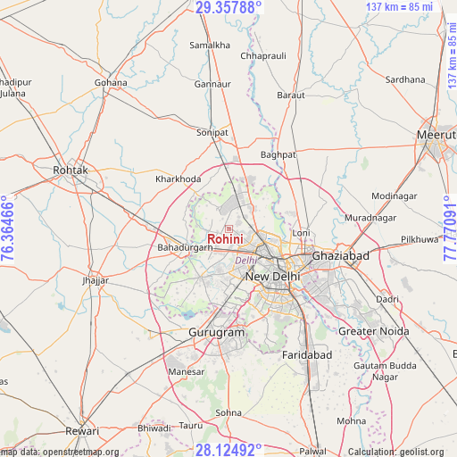
Rohini GPS coordinates[2]
28° 44' 35.592" North, 77° 4' 4.008" East
| Map corner | latitude | longitude |
|---|---|---|
| Upper-left | 29.35788°, | 76.36466° |
| Center: | 28.74322°, | 77.06778° |
| Lower-right: | 28.12492°, | 77.77091° |
| Map W x H: | 137.1×137.1 km | = 85.2×85.2mi |
| max Lat: | 34.9274° ⇑11.9% North |
| Rohini: | 28.74322° |
| min Lat: | ⇓88.1% South 8.09008° |
| min Long | Rohini | max Long |
| 68.82655° | 77.06778° | 96.81° |
| W 37.7%⇐ | ⇒62.3% E |
Elevation
Elevation of Rohini is 212 m = 696 ft, and this is 83.6 m = 274 ft below average elevation for this country.
| Max E: |
3681 m = 12077 ft | 48.3% |
| Avg. | 295.6 m = 970 ft | |
| Rohini | 212 m = 696 ft | |
Min E: |
1 m = 3 ft | 51.7% |
See also: Rohini elevation on elevation.city.
Geographical zone
Rohini is located in North temperate zone (between Tropic of Cancer and the Arctic Circle). Distance of this Northern Tropic circle is 590 km =366.6 mi to South.| Distance of | km | miles | from Rohini |
|---|---|---|---|
| North Pole | 6811.1 | 4232.2 | to North |
| Arctic Circle | 4205.2 | 2613 | to North |
| Tropic Cancer | 590 | 366.6 | to South |
| Equator | 3195.9 | 1985.8 | to South |


Nearby cities:
15 places around Rohini: (largest is in red/bold)
• Alīpur
8.9 km =5.5 mi,  45°
45°
• Bahādurgarh
14.1 km =8.8 mi,  246°
246°
• Bawāna
6.9 km =4.3 mi,  331°
331°
• Defence Colony
25 km =15.5 mi,  139°
139°
• Delhi
18.9 km =11.7 mi,  122°
122°
• Karol Bāgh
15.8 km =9.8 mi,  130°
130°
• Kharkhauda
21.5 km =13.4 mi,  314°
314°
• Khekra
25.1 km =15.6 mi,  57°
57°
• Loni
21.7 km =13.5 mi,  87°
87°
• Najafgarh
17.2 km =10.7 mi,  209°
209°
• Narela
12.4 km =7.7 mi,  11°
11°
• New Delhi
19.4 km =12.1 mi, 128°
• Nāngloi Jāt
7.1 km =4.4 mi,  179°
179°
• Pitampura
8.6 km =5.3 mi, 133°
• Shahdara
17.1 km =10.6 mi,  155°
155°
Sources, notices
• [Note1] Compared only with cities in India existing in our database
• [Src1] Map data: © OpenStreetMap contributors (CC-BY-SA)
• [Src2] Other city data from geonames.org with taken over terms of usage.
• [Src3] Geographical zone / Annual Mean Temperature by Robert A. Rohde @ Wikipedia
