Karol Bāgh geodata
Karol Bāgh (Delhi) is a section of populated place; located in India in Asia/Kolkata (GMT+5.5) time zone. With population of 505,241 people, there are 89 cities with bigger population in this country. Compared to other cities in India, 87.6% of cities are located further ↓South; 61.1% of cities are located further →East and 56.2% of cities have lower elevation than Karol Bāgh. Note1


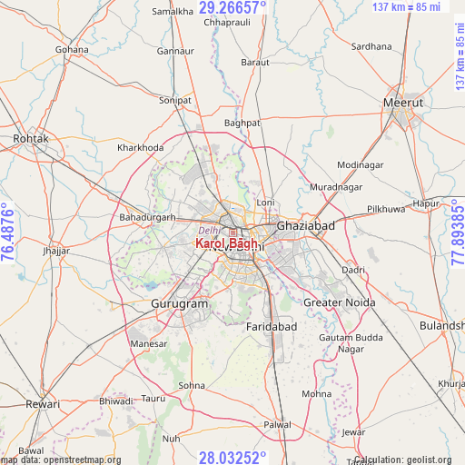
Karol Bāgh GPS coordinates[2]
28° 39' 4.896" North, 77° 11' 26.592" East
| Map corner | latitude | longitude |
|---|---|---|
| Upper-left | 29.26657°, | 76.4876° |
| Center: | 28.65136°, | 77.19072° |
| Lower-right: | 28.03252°, | 77.89385° |
| Map W x H: | 137.2×137.2 km | = 85.3×85.3mi |
| max Lat: | 34.9274° ⇑12.4% North |
| Karol Bāgh: | 28.65136° |
| min Lat: | ⇓87.6% South 8.09008° |
| min Long | Karol Bāgh | max Long |
| 68.82655° | 77.19072° | 96.81° |
| W 38.9%⇐ | ⇒61.1% E |
Elevation
Elevation of Karol Bāgh is 231 m = 758 ft, and this is 64.6 m = 212 ft below average elevation for this country.
| Max E: |
3681 m = 12077 ft | 43.8% |
| Avg. | 295.6 m = 970 ft | |
| Karol Bāgh | 231 m = 758 ft | |
Min E: |
1 m = 3 ft | 56.2% |
See also: Karol Bāgh elevation on elevation.city.
Geographical zone
Karol Bāgh is located in North temperate zone (between Tropic of Cancer and the Arctic Circle). Distance of this Northern Tropic circle is 579.8 km =360.3 mi to South.| Distance of | km | miles | from Karol Bāgh |
|---|---|---|---|
| North Pole | 6821.3 | 4238.6 | to North |
| Arctic Circle | 4215.4 | 2619.3 | to North |
| Tropic Cancer | 579.8 | 360.3 | to South |
| Equator | 3185.7 | 1979.5 | to South |


Nearby cities:
15 places around Karol Bāgh: (largest is in red/bold)
• Alīpur
17.3 km =10.7 mi,  341°
341°
• Bawāna
22.3 km =13.9 mi,  316°
316°
• Defence Colony
9.8 km =6.1 mi,  155°
155°
• Delhi
4 km =2.5 mi,  89°
89°
• Deoli
17 km =10.6 mi,  166°
166°
• Ghāziābād
24.3 km =15.1 mi, 86°
• Loni
14.8 km =9.2 mi,  41°
41°
• Najafgarh
21.1 km =13.1 mi,  257°
257°
• New Delhi
3.7 km =2.3 mi,  117°
117°
• Noida
15.7 km =9.8 mi, 120°
• Nāngloi Jāt
12.4 km =7.7 mi,  284°
284°
• Pitampura
7.2 km =4.5 mi,  306°
306°
• Rohini
15.8 km =9.8 mi, 310°
• Sector
16 km =9.9 mi, 124°
• Shahdara
7.3 km =4.5 mi,  222°
222°
Sources, notices
• [Note1] Compared only with cities in India existing in our database
• [Src1] Map data: © OpenStreetMap contributors (CC-BY-SA)
• [Src2] Other city data from geonames.org with taken over terms of usage.
• [Src3] Geographical zone / Annual Mean Temperature by Robert A. Rohde @ Wikipedia
