Pitampura geodata
Pitampura (Delhi) is a populated place; located in India in Asia/Kolkata (GMT+5.5) time zone. With population of 2,000 people, there are 3431 cities with bigger population in this country. Compared to other cities in India, 87.8% of cities are located further ↓South; 61.7% of cities are located further →East and 52.8% of cities have lower elevation than Pitampura. Note1


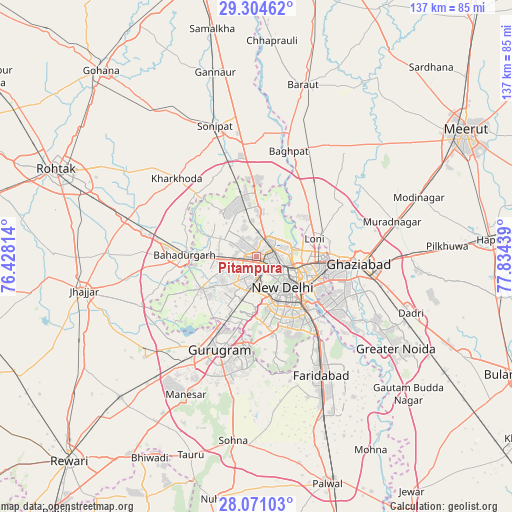
Pitampura GPS coordinates[2]
28° 41' 22.704" North, 77° 7' 52.536" East
| Map corner | latitude | longitude |
|---|---|---|
| Upper-left | 29.30462°, | 76.42814° |
| Center: | 28.68964°, | 77.13126° |
| Lower-right: | 28.07103°, | 77.83439° |
| Map W x H: | 137.2×137.2 km | = 85.3×85.3mi |
| max Lat: | 34.9274° ⇑12.2% North |
| Pitampura: | 28.68964° |
| min Lat: | ⇓87.8% South 8.09008° |
| min Long | Pitampura | max Long |
| 68.82655° | 77.13126° | 96.81° |
| W 38.3%⇐ | ⇒61.7% E |
Elevation
Elevation of Pitampura is 217 m = 712 ft, and this is 78.6 m = 258 ft below average elevation for this country.
| Max E: |
3681 m = 12077 ft | 47.2% |
| Avg. | 295.6 m = 970 ft | |
| Pitampura | 217 m = 712 ft | |
Min E: |
1 m = 3 ft | 52.8% |
See also: India elevation on elevation.city.
Geographical zone
Pitampura is located in North temperate zone (between Tropic of Cancer and the Arctic Circle). Distance of this Northern Tropic circle is 584.1 km =362.9 mi to South.| Distance of | km | miles | from Pitampura |
|---|---|---|---|
| North Pole | 6817.1 | 4235.9 | to North |
| Arctic Circle | 4211.2 | 2616.7 | to North |
| Tropic Cancer | 584.1 | 362.9 | to South |
| Equator | 3190 | 1982.2 | to South |


Nearby cities:
15 places around Pitampura: (largest is in red/bold)
• Alīpur
12.1 km =7.5 mi,  0°
0°
• Bahādurgarh
19.1 km =11.9 mi,  271°
271°
• Bawāna
15.3 km =9.5 mi,  321°
321°
• Defence Colony
16.5 km =10.3 mi,  143°
143°
• Delhi
10.6 km =6.6 mi,  113°
113°
• Deoli
23 km =14.3 mi,  154°
154°
• Karol Bāgh
7.2 km =4.5 mi,  126°
126°
• Loni
17 km =10.6 mi,  66°
66°
• Najafgarh
17.3 km =10.7 mi,  238°
238°
• Narela
18.5 km =11.5 mi,  348°
348°
• New Delhi
10.9 km =6.8 mi,  123°
123°
• Noida
22.9 km =14.2 mi, 122°
• Nāngloi Jāt
6.3 km =3.9 mi,  259°
259°
• Rohini
8.6 km =5.3 mi,  313°
313°
• Shahdara
9.7 km =6 mi,  175°
175°
Sources, notices
• [Note1] Compared only with cities in India existing in our database
• [Src1] Map data: © OpenStreetMap contributors (CC-BY-SA)
• [Src2] Other city data from geonames.org with taken over terms of usage.
• [Src3] Geographical zone / Annual Mean Temperature by Robert A. Rohde @ Wikipedia
