Alīpur geodata
Alīpur (Delhi) is a populated place; located in India in Asia/Kolkata (GMT+5.5) time zone. With population of 20,736 people, there are 1989 cities with bigger population in this country. Compared to other cities in India, 88.3% of cities are located further ↓South; 61.6% of cities are located further →East and 51.9% of cities have lower elevation than Alīpur. Note1


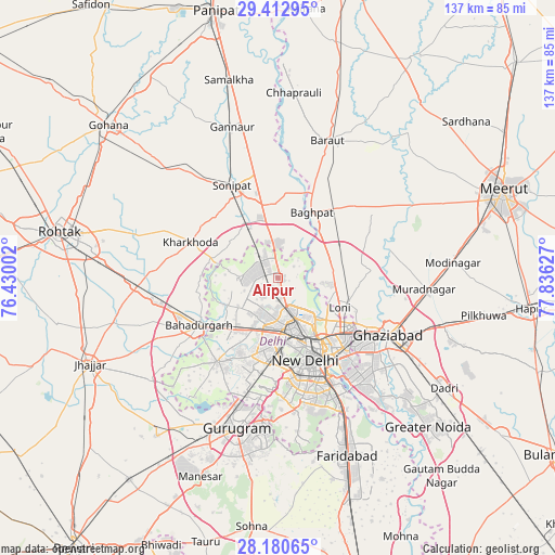
Alīpur GPS coordinates[2]
28° 47' 55.032" North, 77° 7' 59.304" East
| Map corner | latitude | longitude |
|---|---|---|
| Upper-left | 29.41295°, | 76.43002° |
| Center: | 28.79862°, | 77.13314° |
| Lower-right: | 28.18065°, | 77.83627° |
| Map W x H: | 137×137 km | = 85.1×85.1mi |
| max Lat: | 34.9274° ⇑11.7% North |
| Alīpur: | 28.79862° |
| min Lat: | ⇓88.3% South 8.09008° |
| min Long | Alīpur | max Long |
| 68.82655° | 77.13314° | 96.81° |
| W 38.4%⇐ | ⇒61.6% E |
Elevation
Elevation of Alīpur is 213 m = 699 ft, and this is 82.6 m = 271 ft below average elevation for this country.
| Max E: |
3681 m = 12077 ft | 48.1% |
| Avg. | 295.6 m = 970 ft | |
| Alīpur | 213 m = 699 ft | |
Min E: |
1 m = 3 ft | 51.9% |
See also: India elevation on elevation.city.
Geographical zone
Alīpur is located in North temperate zone (between Tropic of Cancer and the Arctic Circle). Distance of this Northern Tropic circle is 596.2 km =370.5 mi to South.| Distance of | km | miles | from Alīpur |
|---|---|---|---|
| North Pole | 6805 | 4228.4 | to North |
| Arctic Circle | 4199.1 | 2609.2 | to North |
| Tropic Cancer | 596.2 | 370.5 | to South |
| Equator | 3202.1 | 1989.7 | to South |


Nearby cities:
15 places around Alīpur: (largest is in red/bold)
• Bahādurgarh
22.6 km =14 mi,  238°
238°
• Bawāna
9.6 km =6 mi,  269°
269°
• Bāghpat
18.3 km =11.4 mi,  27°
27°
• Delhi
18.9 km =11.7 mi,  149°
149°
• Karol Bāgh
17.3 km =10.7 mi,  161°
161°
• Kharkhauda
23.4 km =14.5 mi,  292°
292°
• Khekra
16.5 km =10.3 mi,  63°
63°
• Loni
16.2 km =10.1 mi,  108°
108°
• Narela
7.2 km =4.5 mi,  326°
326°
• New Delhi
20.2 km =12.6 mi, 153°
• Nāngloi Jāt
14.7 km =9.1 mi,  205°
205°
• Pitampura
12.1 km =7.5 mi,  180°
180°
• Rohini
8.9 km =5.5 mi,  225°
225°
• Shahdara
21.7 km =13.5 mi, 178°
• Sonīpat
24.5 km =15.2 mi, 333°
Sources, notices
• [Note1] Compared only with cities in India existing in our database
• [Src1] Map data: © OpenStreetMap contributors (CC-BY-SA)
• [Src2] Other city data from geonames.org with taken over terms of usage.
• [Src3] Geographical zone / Annual Mean Temperature by Robert A. Rohde @ Wikipedia
