Loni geodata
Loni (Uttar Pradesh) is a populated place; located in India in Asia/Kolkata (GMT+5.5) time zone. With population of 164,810 people, there are 261 cities with bigger population in this country. Compared to other cities in India, 88.1% of cities are located further ↓South; 59.9% of cities are located further →East and 51.9% of cities have lower elevation than Loni. Note1


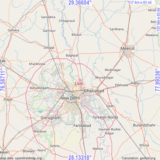
Loni GPS coordinates[2]
28° 45' 5.148" North, 77° 17' 24.828" East
| Map corner | latitude | longitude |
|---|---|---|
| Upper-left | 29.36604°, | 76.58711° |
| Center: | 28.75143°, | 77.29023° |
| Lower-right: | 28.13318°, | 77.99336° |
| Map W x H: | 137.1×137.1 km | = 85.2×85.2mi |
| max Lat: | 34.9274° ⇑11.9% North |
| Loni: | 28.75143° |
| min Lat: | ⇓88.1% South 8.09008° |
| min Long | Loni | max Long |
| 68.82655° | 77.29023° | 96.81° |
| W 40.1%⇐ | ⇒59.9% E |
Elevation
Elevation of Loni is 213 m = 699 ft, and this is 82.6 m = 271 ft below average elevation for this country.
| Max E: |
3681 m = 12077 ft | 48.1% |
| Avg. | 295.6 m = 970 ft | |
| Loni | 213 m = 699 ft | |
Min E: |
1 m = 3 ft | 51.9% |
See also: Loni elevation on elevation.city.
Geographical zone
Loni is located in North temperate zone (between Tropic of Cancer and the Arctic Circle). Distance of this Northern Tropic circle is 590.9 km =367.2 mi to South.| Distance of | km | miles | from Loni |
|---|---|---|---|
| North Pole | 6810.2 | 4231.7 | to North |
| Arctic Circle | 4204.3 | 2612.4 | to North |
| Tropic Cancer | 590.9 | 367.2 | to South |
| Equator | 3196.9 | 1986.5 | to South |


Nearby cities:
15 places around Loni: (largest is in red/bold)
• Alīpur
16.2 km =10.1 mi,  288°
288°
• Bāghpat
22.6 km =14 mi,  342°
342°
• Defence Colony
20.8 km =12.9 mi,  195°
195°
• Delhi
12.5 km =7.8 mi,  207°
207°
• Ghāziābād
17.4 km =10.8 mi,  123°
123°
• Karol Bāgh
14.8 km =9.2 mi,  221°
221°
• Khekra
12.7 km =7.9 mi,  357°
357°
• Murādnagar
20.6 km =12.8 mi,  80°
80°
• Narela
22.3 km =13.9 mi,  300°
300°
• New Delhi
14.4 km =8.9 mi, 206°
• Noida
19.5 km =12.1 mi,  168°
168°
• Pitampura
17 km =10.6 mi,  246°
246°
• Rohini
21.7 km =13.5 mi,  267°
267°
• Sector
20.4 km =12.7 mi, 170°
• Shahdara
22.1 km =13.7 mi, 221°
Sources, notices
• [Note1] Compared only with cities in India existing in our database
• [Src1] Map data: © OpenStreetMap contributors (CC-BY-SA)
• [Src2] Other city data from geonames.org with taken over terms of usage.
• [Src3] Geographical zone / Annual Mean Temperature by Robert A. Rohde @ Wikipedia
