Najafgarh geodata
Najafgarh (Delhi) is a populated place; located in India in Asia/Kolkata (GMT+5.5) time zone. With population of 1,365,000 people, there are 21 cities with bigger population in this country. Compared to other cities in India, 87.2% of cities are located further ↓South; 63.3% of cities are located further →East and 52.5% of cities have lower elevation than Najafgarh. Note1


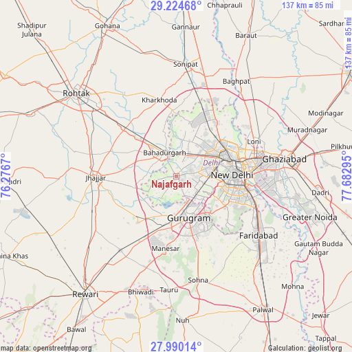
Najafgarh GPS coordinates[2]
28° 36' 33.192" North, 76° 58' 47.352" East
| Map corner | latitude | longitude |
|---|---|---|
| Upper-left | 29.22468°, | 76.2767° |
| Center: | 28.60922°, | 76.97982° |
| Lower-right: | 27.99014°, | 77.68295° |
| Map W x H: | 137.3×137.3 km | = 85.3×85.3mi |
| max Lat: | 34.9274° ⇑12.8% North |
| Najafgarh: | 28.60922° |
| min Lat: | ⇓87.2% South 8.09008° |
| min Long | Najafgarh | max Long |
| 68.82655° | 76.97982° | 96.81° |
| W 36.7%⇐ | ⇒63.3% E |
Elevation
Elevation of Najafgarh is 215 m = 705 ft, and this is 80.6 m = 264 ft below average elevation for this country.
| Max E: |
3681 m = 12077 ft | 47.5% |
| Avg. | 295.6 m = 970 ft | |
| Najafgarh | 215 m = 705 ft | |
Min E: |
1 m = 3 ft | 52.5% |
See also: Najafgarh elevation on elevation.city.
Geographical zone
Najafgarh is located in North temperate zone (between Tropic of Cancer and the Arctic Circle). Distance of this Northern Tropic circle is 575.1 km =357.4 mi to South.| Distance of | km | miles | from Najafgarh |
|---|---|---|---|
| North Pole | 6826 | 4241.5 | to North |
| Arctic Circle | 4220.1 | 2622.2 | to North |
| Tropic Cancer | 575.1 | 357.4 | to South |
| Equator | 3181 | 1976.6 | to South |


Nearby cities:
15 places around Najafgarh: (largest is in red/bold)
• Alīpur
25.8 km =16 mi,  35°
35°
• Bahādurgarh
10.3 km =6.4 mi,  335°
335°
• Bawāna
21.7 km =13.5 mi,  14°
14°
• Defence Colony
25 km =15.5 mi,  99°
99°
• Delhi
25 km =15.5 mi,  79°
79°
• Deoli
27.3 km =17 mi,  115°
115°
• Farrukhnagar
23.6 km =14.7 mi,  220°
220°
• Gurgaon
17.2 km =10.7 mi,  164°
164°
• Karol Bāgh
21.1 km =13.1 mi, 77°
• Kheri Sāmpla
27.4 km =17 mi,  313°
313°
• New Delhi
24.1 km =15 mi, 82°
• Nāngloi Jāt
11.6 km =7.2 mi,  47°
47°
• Pitampura
17.3 km =10.7 mi,  58°
58°
• Rohini
17.2 km =10.7 mi,  29°
29°
• Shahdara
15.6 km =9.7 mi,  92°
92°
Sources, notices
• [Note1] Compared only with cities in India existing in our database
• [Src1] Map data: © OpenStreetMap contributors (CC-BY-SA)
• [Src2] Other city data from geonames.org with taken over terms of usage.
• [Src3] Geographical zone / Annual Mean Temperature by Robert A. Rohde @ Wikipedia
