Farrukhnagar geodata
Farrukhnagar (Haryana) is a populated place; located in India in Asia/Kolkata (GMT+5.5) time zone. With population of 10,091 people, there are 2933 cities with bigger population in this country. Compared to other cities in India, 86.5% of cities are located further ↓South; 65% of cities are located further →East and 54% of cities have lower elevation than Farrukhnagar. Note1


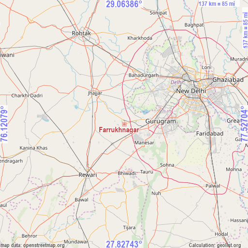
Farrukhnagar GPS coordinates[2]
28° 26' 50.82" North, 76° 49' 26.076" East
| Map corner | latitude | longitude |
|---|---|---|
| Upper-left | 29.06386°, | 76.12079° |
| Center: | 28.44745°, | 76.82391° |
| Lower-right: | 27.82743°, | 77.52704° |
| Map W x H: | 137.5×137.5 km | = 85.4×85.4mi |
| max Lat: | 34.9274° ⇑13.5% North |
| Farrukhnagar: | 28.44745° |
| min Lat: | ⇓86.5% South 8.09008° |
| min Long | Farrukhnagar | max Long |
| 68.82655° | 76.82391° | 96.81° |
| W 35%⇐ | ⇒65% E |
Elevation
Elevation of Farrukhnagar is 222 m = 728 ft, and this is 73.6 m = 241 ft below average elevation for this country.
| Max E: |
3681 m = 12077 ft | 46% |
| Avg. | 295.6 m = 970 ft | |
| Farrukhnagar | 222 m = 728 ft | |
Min E: |
1 m = 3 ft | 54% |
See also: India elevation on elevation.city.
Geographical zone
Farrukhnagar is located in North temperate zone (between Tropic of Cancer and the Arctic Circle). Distance of this Northern Tropic circle is 557.1 km =346.2 mi to South.| Distance of | km | miles | from Farrukhnagar |
|---|---|---|---|
| North Pole | 6844 | 4252.7 | to North |
| Arctic Circle | 4238.1 | 2633.4 | to North |
| Tropic Cancer | 557.1 | 346.2 | to South |
| Equator | 3163.1 | 1965.5 | to South |


Nearby cities:
15 places around Farrukhnagar: (largest is in red/bold)
• Bahādurgarh
29.4 km =18.3 mi,  21°
21°
• Beri Khās
37.1 km =23.1 mi,  319°
319°
• Bhiwadi
26.6 km =16.5 mi,  172°
172°
• Dhāruhera
27 km =16.8 mi,  185°
185°
• Gurgaon
19.8 km =12.3 mi,  85°
85°
• Jhajjar
24.1 km =15 mi, 317°
• Kheri Sāmpla
37.1 km =23.1 mi,  352°
352°
• Najafgarh
23.6 km =14.7 mi,  40°
40°
• Nāngloi Jāt
35.1 km =21.8 mi, 42°
• Pataudi
14.3 km =8.9 mi,  198°
198°
• Pitampura
40.3 km =25 mi,  48°
48°
• Rewāri
34.2 km =21.3 mi,  216°
216°
• Shahdara
35.4 km =22 mi,  60°
60°
• Sohna
32.5 km =20.2 mi,  133°
133°
• Tāoru
29 km =18 mi,  154°
154°
Sources, notices
• [Note1] Compared only with cities in India existing in our database
• [Src1] Map data: © OpenStreetMap contributors (CC-BY-SA)
• [Src2] Other city data from geonames.org with taken over terms of usage.
• [Src3] Geographical zone / Annual Mean Temperature by Robert A. Rohde @ Wikipedia
