Pīpār geodata
Pīpār (Rajasthan) is a populated place; located in India in Asia/Kolkata (GMT+5.5) time zone. With population of 34,630 people, there are 1254 cities with bigger population in this country. Compared to other cities in India, 73.7% of cities are located further ↓South; 92.4% of cities are located further →East and 61.2% of cities have lower elevation than Pīpār. Note1


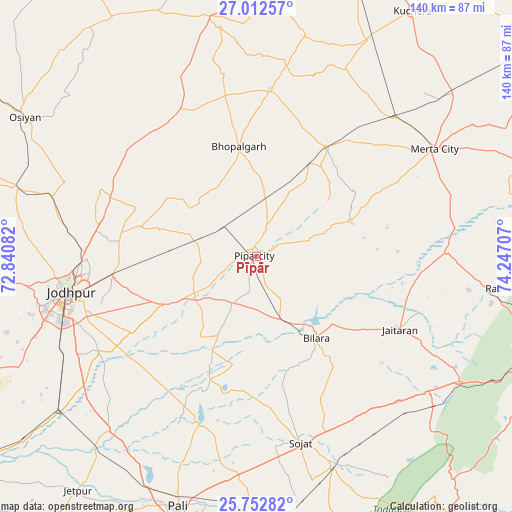
Pīpār GPS coordinates[2]
26° 23' 3.876" North, 73° 32' 38.184" East
| Map corner | latitude | longitude |
|---|---|---|
| Upper-left | 27.01257°, | 72.84082° |
| Center: | 26.38441°, | 73.54394° |
| Lower-right: | 25.75282°, | 74.24707° |
| Map W x H: | 140.1×140.1 km | = 87.1×87.1mi |
| max Lat: | 34.9274° ⇑26.3% North |
| Pīpār: | 26.38441° |
| min Lat: | ⇓73.7% South 8.09008° |
| min Long | Pīpār | max Long |
| 68.82655° | 73.54394° | 96.81° |
| W 7.6%⇐ | ⇒92.4% E |
Elevation
Elevation of Pīpār is 259 m = 850 ft, and this is 36.6 m = 120 ft below average elevation for this country.
| Max E: |
3681 m = 12077 ft | 38.8% |
| Avg. | 295.6 m = 970 ft | |
| Pīpār | 259 m = 850 ft | |
Min E: |
1 m = 3 ft | 61.2% |
See also: India elevation on elevation.city.
Geographical zone
Pīpār is located in North temperate zone (between Tropic of Cancer and the Arctic Circle). Distance of this Northern Tropic circle is 327.8 km =203.7 mi to South.| Distance of | km | miles | from Pīpār |
|---|---|---|---|
| North Pole | 7073.4 | 4395.2 | to North |
| Arctic Circle | 4467.5 | 2776 | to North |
| Tropic Cancer | 327.8 | 203.7 | to South |
| Equator | 2933.7 | 1822.9 | to South |


Nearby cities:
15 places around Pīpār: (largest is in red/bold)
• Basni
88.2 km =54.8 mi,  6°
6°
• Beāwar
83.6 km =51.9 mi,  112°
112°
• Bilāra
27.8 km =17.3 mi,  144°
144°
• Devgarh
102.2 km =63.5 mi,  159°
159°
• Jaitāran
44 km =27.3 mi,  117°
117°
• Jodhpur
55.1 km =34.2 mi,  256°
256°
• Kuchera
79.4 km =49.3 mi,  32°
32°
• Merta
56.9 km =35.4 mi,  58°
58°
• Mūndwa
80.4 km =50 mi,  20°
20°
• Nāgaur
92.8 km =57.7 mi, 11°
• Nīmāj
52.5 km =32.6 mi, 119°
• Pushkar
101.1 km =62.8 mi,  83°
83°
• Pāli
71.5 km =44.4 mi,  197°
197°
• Raipur
61.1 km =38 mi,  128°
128°
• Sojat
52.5 km =32.6 mi,  166°
166°
Sources, notices
• [Note1] Compared only with cities in India existing in our database
• [Src1] Map data: © OpenStreetMap contributors (CC-BY-SA)
• [Src2] Other city data from geonames.org with taken over terms of usage.
• [Src3] Geographical zone / Annual Mean Temperature by Robert A. Rohde @ Wikipedia
