Nādbai geodata
Nādbai (Rajasthan) is a populated place; located in India in Asia/Kolkata (GMT+5.5) time zone. With population of 23,520 people, there are 1799 cities with bigger population in this country. Compared to other cities in India, 80.3% of cities are located further ↓South; 61.1% of cities are located further →East and 50.1% of cities have lower elevation than Nādbai. Note1


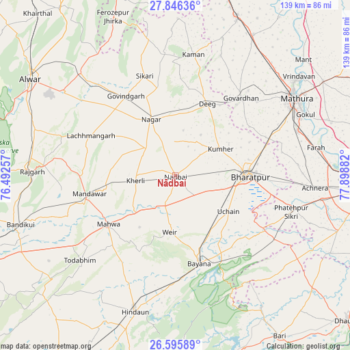
Nādbai GPS coordinates[2]
27° 13' 22.368" North, 77° 11' 44.484" East
| Map corner | latitude | longitude |
|---|---|---|
| Upper-left | 27.84636°, | 76.49257° |
| Center: | 27.22288°, | 77.19569° |
| Lower-right: | 26.59589°, | 77.89882° |
| Map W x H: | 139×139 km | = 86.4×86.4mi |
| max Lat: | 34.9274° ⇑19.7% North |
| Nādbai: | 27.22288° |
| min Lat: | ⇓80.3% South 8.09008° |
| min Long | Nādbai | max Long |
| 68.82655° | 77.19569° | 96.81° |
| W 38.9%⇐ | ⇒61.1% E |
Elevation
Elevation of Nādbai is 201 m = 659 ft, and this is 94.6 m = 310 ft below average elevation for this country.
| Max E: |
3681 m = 12077 ft | 49.9% |
| Avg. | 295.6 m = 970 ft | |
| Nādbai | 201 m = 659 ft | |
Min E: |
1 m = 3 ft | 50.1% |
See also: India elevation on elevation.city.
Geographical zone
Nādbai is located in North temperate zone (between Tropic of Cancer and the Arctic Circle). Distance of this Northern Tropic circle is 421 km =261.6 mi to South.| Distance of | km | miles | from Nādbai |
|---|---|---|---|
| North Pole | 6980.2 | 4337.3 | to North |
| Arctic Circle | 4374.3 | 2718.1 | to North |
| Tropic Cancer | 421 | 261.6 | to South |
| Equator | 3026.9 | 1880.8 | to South |


Nearby cities:
15 places around Nādbai: (largest is in red/bold)
• Barsāna
50.5 km =31.4 mi,  20°
20°
• Bayāna
36.2 km =22.5 mi,  165°
165°
• Bharatpur
29.1 km =18.1 mi,  91°
91°
• Bhasāwar
25.1 km =15.6 mi,  215°
215°
• Dīg
30.5 km =19 mi, 24°
• Fatehpur Sīkri
48.1 km =29.9 mi,  107°
107°
• Govardhan
40.3 km =25 mi,  40°
40°
• Govindgarh
36.8 km =22.9 mi,  328°
328°
• Kāman
48.9 km =30.4 mi,  8°
8°
• Kūmher
20.2 km =12.6 mi,  58°
58°
• Mahwah
32.7 km =20.3 mi,  233°
233°
• Nagar
24.3 km =15.1 mi,  336°
336°
• Rādhākund
44.4 km =27.6 mi, 41°
• Todabhim
50.7 km =31.5 mi, 227°
• Wer
22.8 km =14.2 mi,  184°
184°
Sources, notices
• [Note1] Compared only with cities in India existing in our database
• [Src1] Map data: © OpenStreetMap contributors (CC-BY-SA)
• [Src2] Other city data from geonames.org with taken over terms of usage.
• [Src3] Geographical zone / Annual Mean Temperature by Robert A. Rohde @ Wikipedia
