Mahwah geodata
Mahwah (Rajasthan) is a populated place; located in India in Asia/Kolkata (GMT+5.5) time zone. With population of 22,624 people, there are 1863 cities with bigger population in this country. Compared to other cities in India, 78.7% of cities are located further ↓South; 64.1% of cities are located further →East and 57.4% of cities have lower elevation than Mahwah. Note1


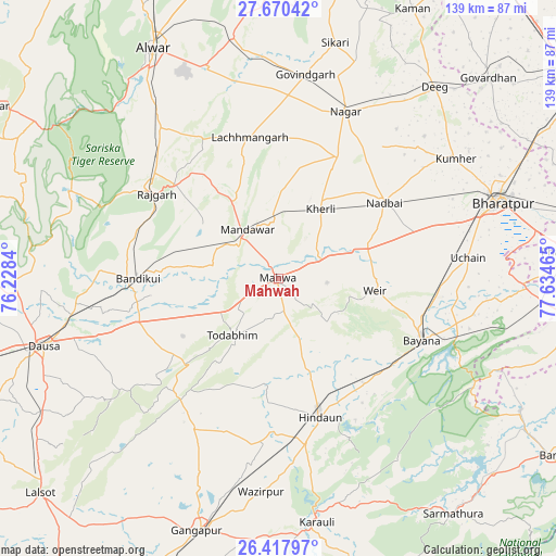
Mahwah GPS coordinates[2]
27° 2' 45.384" North, 76° 55' 53.472" East
| Map corner | latitude | longitude |
|---|---|---|
| Upper-left | 27.67042°, | 76.2284° |
| Center: | 27.04594°, | 76.93152° |
| Lower-right: | 26.41797°, | 77.63465° |
| Map W x H: | 139.3×139.3 km | = 86.6×86.6mi |
| max Lat: | 34.9274° ⇑21.3% North |
| Mahwah: | 27.04594° |
| min Lat: | ⇓78.7% South 8.09008° |
| min Long | Mahwah | max Long |
| 68.82655° | 76.93152° | 96.81° |
| W 35.9%⇐ | ⇒64.1% E |
Elevation
Elevation of Mahwah is 237 m = 778 ft, and this is 58.6 m = 192 ft below average elevation for this country.
| Max E: |
3681 m = 12077 ft | 42.6% |
| Avg. | 295.6 m = 970 ft | |
| Mahwah | 237 m = 778 ft | |
Min E: |
1 m = 3 ft | 57.4% |
See also: India elevation on elevation.city.
Geographical zone
Mahwah is located in North temperate zone (between Tropic of Cancer and the Arctic Circle). Distance of this Northern Tropic circle is 401.3 km =249.4 mi to South.| Distance of | km | miles | from Mahwah |
|---|---|---|---|
| North Pole | 6999.8 | 4349.5 | to North |
| Arctic Circle | 4393.9 | 2730.2 | to North |
| Tropic Cancer | 401.3 | 249.4 | to South |
| Equator | 3007.2 | 1868.6 | to South |


Nearby cities:
15 places around Mahwah: (largest is in red/bold)
• Abhaneri
32.4 km =20.1 mi,  262°
262°
• Baswa
36.3 km =22.6 mi,  288°
288°
• Bayāna
38.7 km =24 mi,  113°
113°
• Bharatpur
58.5 km =36.4 mi,  70°
70°
• Bhasāwar
11.6 km =7.2 mi,  93°
93°
• Bāndīkūi
35.5 km =22.1 mi,  270°
270°
• Dīg
61.3 km =38.1 mi,  39°
39°
• Govindgarh
51.4 km =31.9 mi,  7°
7°
• Hindaun
36.2 km =22.5 mi,  163°
163°
• Kūmher
52.9 km =32.9 mi,  55°
55°
• Nagar
45.2 km =28.1 mi,  21°
21°
• Nādbai
32.7 km =20.3 mi,  53°
53°
• Rājgarh
37.3 km =23.2 mi,  304°
304°
• Todabhim
18.3 km =11.4 mi,  218°
218°
• Wer
24.4 km =15.2 mi,  97°
97°
Sources, notices
• [Note1] Compared only with cities in India existing in our database
• [Src1] Map data: © OpenStreetMap contributors (CC-BY-SA)
• [Src2] Other city data from geonames.org with taken over terms of usage.
• [Src3] Geographical zone / Annual Mean Temperature by Robert A. Rohde @ Wikipedia
