Jalesar geodata
Jalesar (Uttar Pradesh) is a populated place; located in India in Asia/Kolkata (GMT+5.5) time zone. With population of 38,614 people, there are 1139 cities with bigger population in this country. Compared to other cities in India, 81.6% of cities are located further ↓South; 52.4% of cities are located further ←West and 54.3% of cities have higher elevation than Jalesar. Note1


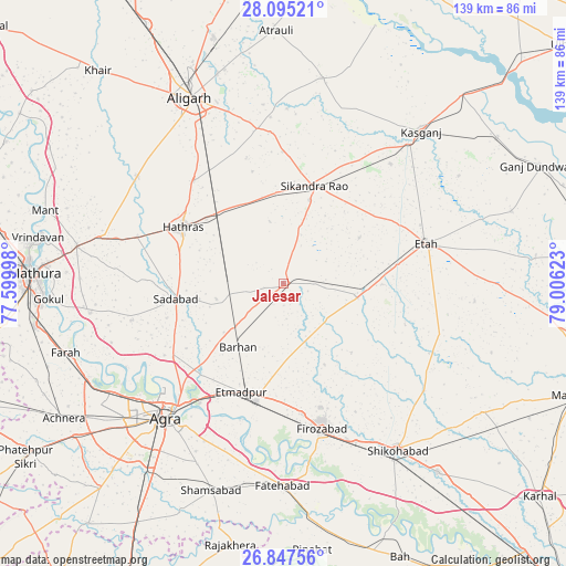
Jalesar GPS coordinates[2]
27° 28' 23.34" North, 78° 18' 11.16" East
| Map corner | latitude | longitude |
|---|---|---|
| Upper-left | 28.09521°, | 77.59998° |
| Center: | 27.47315°, | 78.3031° |
| Lower-right: | 26.84756°, | 79.00623° |
| Map W x H: | 138.7×138.7 km | = 86.2×86.2mi |
| max Lat: | 34.9274° ⇑18.4% North |
| Jalesar: | 27.47315° |
| min Lat: | ⇓81.6% South 8.09008° |
| min Long | Jalesar | max Long |
| 68.82655° | 78.3031° | 96.81° |
| W 52.4%⇐ | ⇒47.6% E |
Elevation
Elevation of Jalesar is 179 m = 587 ft, and this is 116.6 m = 383 ft below average elevation for this country.
| Max E: |
3681 m = 12077 ft | 54.3% |
| Avg. | 295.6 m = 970 ft | |
| Jalesar | 179 m = 587 ft | |
Min E: |
1 m = 3 ft | 45.7% |
See also: India elevation on elevation.city.
Geographical zone
Jalesar is located in North temperate zone (between Tropic of Cancer and the Arctic Circle). Distance of this Northern Tropic circle is 448.8 km =278.9 mi to South.| Distance of | km | miles | from Jalesar |
|---|---|---|---|
| North Pole | 6952.3 | 4320 | to North |
| Arctic Circle | 4346.4 | 2700.7 | to North |
| Tropic Cancer | 448.8 | 278.9 | to South |
| Equator | 3054.7 | 1898.1 | to South |


Nearby cities:
15 places around Jalesar: (largest is in red/bold)
• Agra
42.9 km =26.7 mi,  221°
221°
• Dayāl Bāgh
40.2 km =25 mi,  225°
225°
• Fīrozābād
37 km =23 mi,  165°
165°
• Hāthras
28.2 km =17.5 mi,  298°
298°
• Iglās
44.5 km =27.7 mi,  306°
306°
• Itimādpur
28.4 km =17.6 mi,  201°
201°
• Jalālī
44.1 km =27.4 mi,  353°
353°
• Jasrāna
43.4 km =27 mi,  127°
127°
• Mursān
37.6 km =23.4 mi,  288°
288°
• Mārahra
39.3 km =24.4 mi,  41°
41°
• Pharihā
23.7 km =14.7 mi,  135°
135°
• Sadābād
26.5 km =16.5 mi,  261°
261°
• Sikandra Rao
25.1 km =15.6 mi,  17°
17°
• Sāsni
33.5 km =20.8 mi,  319°
319°
• Tūndla
29.5 km =18.3 mi,  192°
192°
Sources, notices
• [Note1] Compared only with cities in India existing in our database
• [Src1] Map data: © OpenStreetMap contributors (CC-BY-SA)
• [Src2] Other city data from geonames.org with taken over terms of usage.
• [Src3] Geographical zone / Annual Mean Temperature by Robert A. Rohde @ Wikipedia
