Amarpur geodata
Amarpur (Bihar) is a populated place; located in India in Asia/Kolkata (GMT+5.5) time zone. With population of 22,796 people, there are 1848 cities with bigger population in this country. Compared to other cities in India, 63.7% of cities are located further ↓South; 89.1% of cities are located further ←West and 75.9% of cities have higher elevation than Amarpur. Note1


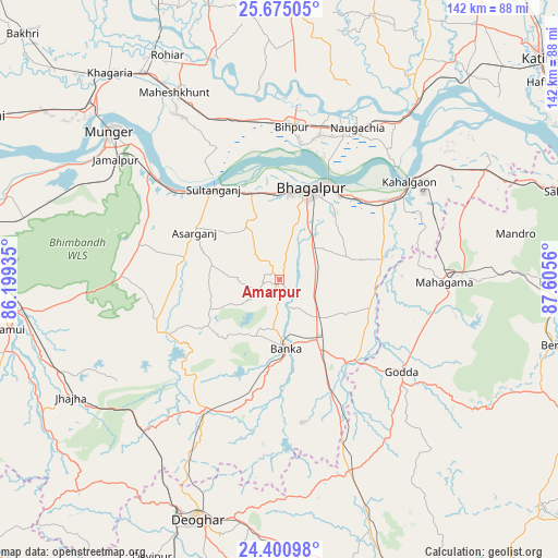
Amarpur GPS coordinates[2]
25° 2' 22.812" North, 86° 54' 8.892" East
| Map corner | latitude | longitude |
|---|---|---|
| Upper-left | 25.67505°, | 86.19935° |
| Center: | 25.03967°, | 86.90247° |
| Lower-right: | 24.40098°, | 87.6056° |
| Map W x H: | 141.7×141.7 km | = 88×88mi |
| max Lat: | 34.9274° ⇑36.3% North |
| Amarpur: | 25.03967° |
| min Lat: | ⇓63.7% South 8.09008° |
| min Long | Amarpur | max Long |
| 68.82655° | 86.90247° | 96.81° |
| W 89.1%⇐ | ⇒10.9% E |
Elevation
Elevation of Amarpur is 64 m = 210 ft, and this is 231.6 m = 760 ft below average elevation for this country.
| Max E: |
3681 m = 12077 ft | 75.9% |
| Avg. | 295.6 m = 970 ft | |
| Amarpur | 64 m = 210 ft | |
Min E: |
1 m = 3 ft | 24.1% |
See also: India elevation on elevation.city.
Geographical zone
Amarpur is located in North temperate zone (between Tropic of Cancer and the Arctic Circle). Distance of this Northern Tropic circle is 178.2 km =110.7 mi to South.| Distance of | km | miles | from Amarpur |
|---|---|---|---|
| North Pole | 7222.9 | 4488.1 | to North |
| Arctic Circle | 4617 | 2868.9 | to North |
| Tropic Cancer | 178.2 | 110.7 | to South |
| Equator | 2784.2 | 1730 | to South |


Nearby cities:
15 places around Amarpur: (largest is in red/bold)
• Asarganj
25 km =15.5 mi,  299°
299°
• Bariārpur
42.9 km =26.7 mi,  310°
310°
• Bhāgalpur
23.8 km =14.8 mi,  17°
17°
• Bānka
17.8 km =11.1 mi,  173°
173°
• Colgong
41.5 km =25.8 mi,  53°
53°
• Ghoga
32.4 km =20.1 mi, 52°
• Godda
39.2 km =24.4 mi,  127°
127°
• Jamālpur
51.5 km =32 mi, 306°
• Jamūī
69.4 km =43.1 mi,  259°
259°
• Jasidih
64 km =39.8 mi,  203°
203°
• Jhā-Jhā
60.7 km =37.7 mi,  240°
240°
• Khagaria
67.5 km =41.9 mi,  319°
319°
• Kharagpur
36.2 km =22.5 mi,  285°
285°
• Monghyr
56.9 km =35.4 mi, 310°
• Naugachhia
43.5 km =27 mi,  27°
27°
Sources, notices
• [Note1] Compared only with cities in India existing in our database
• [Src1] Map data: © OpenStreetMap contributors (CC-BY-SA)
• [Src2] Other city data from geonames.org with taken over terms of usage.
• [Src3] Geographical zone / Annual Mean Temperature by Robert A. Rohde @ Wikipedia
