Asarganj geodata
Asarganj (Bihar) is a populated place; located in India in Asia/Kolkata (GMT+5.5) time zone. With population of 6,020 people, there are 3288 cities with bigger population in this country. Compared to other cities in India, 64.2% of cities are located further ↓South; 88.7% of cities are located further ←West and 79.2% of cities have higher elevation than Asarganj. Note1


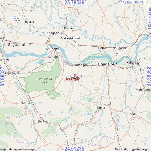
Asarganj GPS coordinates[2]
25° 9' 1.656" North, 86° 41' 11.004" East
| Map corner | latitude | longitude |
|---|---|---|
| Upper-left | 25.78526°, | 85.98327° |
| Center: | 25.15046°, | 86.68639° |
| Lower-right: | 24.51235°, | 87.38952° |
| Map W x H: | 141.5×141.5 km | = 87.9×87.9mi |
| max Lat: | 34.9274° ⇑35.8% North |
| Asarganj: | 25.15046° |
| min Lat: | ⇓64.2% South 8.09008° |
| min Long | Asarganj | max Long |
| 68.82655° | 86.68639° | 96.81° |
| W 88.7%⇐ | ⇒11.3% E |
Elevation
Elevation of Asarganj is 51 m = 167 ft, and this is 244.6 m = 802 ft below average elevation for this country.
| Max E: |
3681 m = 12077 ft | 79.2% |
| Avg. | 295.6 m = 970 ft | |
| Asarganj | 51 m = 167 ft | |
Min E: |
1 m = 3 ft | 20.8% |
See also: India elevation on elevation.city.
Geographical zone
Asarganj is located in North temperate zone (between Tropic of Cancer and the Arctic Circle). Distance of this Northern Tropic circle is 190.6 km =118.4 mi to South.| Distance of | km | miles | from Asarganj |
|---|---|---|---|
| North Pole | 7210.6 | 4480.5 | to North |
| Arctic Circle | 4604.7 | 2861.2 | to North |
| Tropic Cancer | 190.6 | 118.4 | to South |
| Equator | 2796.5 | 1737.7 | to South |


Nearby cities:
15 places around Asarganj: (largest is in red/bold)
• Amarpur
25 km =15.5 mi,  119°
119°
• Bariārpur
18.9 km =11.7 mi,  324°
324°
• Begusarai
63 km =39.1 mi,  298°
298°
• Bhāgalpur
30.6 km =19 mi,  70°
70°
• Bānka
38.3 km =23.8 mi,  141°
141°
• Colgong
56.4 km =35 mi,  77°
77°
• Ghoga
47.9 km =29.8 mi, 81°
• Jamālpur
26.8 km =16.7 mi,  312°
312°
• Jamūī
52.7 km =32.7 mi,  241°
241°
• Jhā-Jhā
52.3 km =32.5 mi,  216°
216°
• Khagaria
44.9 km =27.9 mi,  330°
330°
• Kharagpur
13.5 km =8.4 mi,  257°
257°
• Luckeesarai
59.6 km =37 mi,  272°
272°
• Monghyr
32.8 km =20.4 mi, 319°
• Naugachhia
49.2 km =30.6 mi,  57°
57°
Sources, notices
• [Note1] Compared only with cities in India existing in our database
• [Src1] Map data: © OpenStreetMap contributors (CC-BY-SA)
• [Src2] Other city data from geonames.org with taken over terms of usage.
• [Src3] Geographical zone / Annual Mean Temperature by Robert A. Rohde @ Wikipedia
