Māndal geodata
Māndal (Gujarat) is a populated place; located in India in Asia/Kolkata (GMT+5.5) time zone. With population of 13,345 people, there are 2622 cities with bigger population in this country. Compared to other cities in India, 53.5% of cities are located further ↓South; 97.4% of cities are located further →East and 83.5% of cities have higher elevation than Māndal. Note1


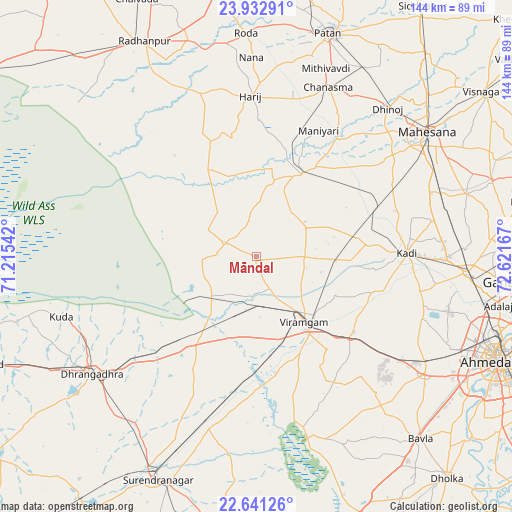
Māndal GPS coordinates[2]
23° 17' 19.14" North, 71° 55' 6.744" East
| Map corner | latitude | longitude |
|---|---|---|
| Upper-left | 23.93291°, | 71.21542° |
| Center: | 23.28865°, | 71.91854° |
| Lower-right: | 22.64126°, | 72.62167° |
| Map W x H: | 143.6×143.6 km | = 89.2×89.2mi |
| max Lat: | 34.9274° ⇑46.5% North |
| Māndal: | 23.28865° |
| min Lat: | ⇓53.5% South 8.09008° |
| min Long | Māndal | max Long |
| 68.82655° | 71.91854° | 96.81° |
| W 2.6%⇐ | ⇒97.4% E |
Elevation
Elevation of Māndal is 35 m = 115 ft, and this is 260.6 m = 855 ft below average elevation for this country.
| Max E: |
3681 m = 12077 ft | 83.5% |
| Avg. | 295.6 m = 970 ft | |
| Māndal | 35 m = 115 ft | |
Min E: |
1 m = 3 ft | 16.5% |
See also: India elevation on elevation.city.
Geographical zone
Māndal is located in North Torrid zone (between Equator and Tropic of Cancer). Distance of this Northern Tropic circle is 16.5 km =10.3 mi to North.| Distance of | km | miles | from Māndal |
|---|---|---|---|
| North Pole | 7417.6 | 4609.1 | to North |
| Arctic Circle | 4811.7 | 2989.9 | to North |
| Tropic Cancer | 16.5 | 10.3 | to North |
| Equator | 2589.5 | 1609 | to South |


Nearby cities:
15 places around Māndal: (largest is in red/bold)
• Adalaj
69.1 km =42.9 mi,  101°
101°
• Ahmedabad
74.4 km =46.2 mi,  113°
113°
• Chānasma
51.3 km =31.9 mi,  22°
22°
• Dhrāngadhra
56.7 km =35.2 mi,  234°
234°
• Hārij
45 km =28 mi,  358°
358°
• Jhulasan
56.8 km =35.3 mi,  85°
85°
• Kadi
42.4 km =26.3 mi, 88°
• Lakhtar
49.8 km =30.9 mi,  195°
195°
• Pātan
66.1 km =41.1 mi, 18°
• Rādhanpur
68.4 km =42.5 mi,  332°
332°
• Sarkhej
68.7 km =42.7 mi,  119°
119°
• Surendranagar
68.3 km =42.4 mi, 203°
• Sānand
57.7 km =35.9 mi, 124°
• Un
68.3 km =42.4 mi,  347°
347°
• Unjha
74.8 km =46.5 mi,  40°
40°
Sources, notices
• [Note1] Compared only with cities in India existing in our database
• [Src1] Map data: © OpenStreetMap contributors (CC-BY-SA)
• [Src2] Other city data from geonames.org with taken over terms of usage.
• [Src3] Geographical zone / Annual Mean Temperature by Robert A. Rohde @ Wikipedia
