Surendranagar geodata
Surendranagar (Gujarat) is a populated place; located in India in Asia/Kolkata (GMT+5.5) time zone. With population of 179,628 people, there are 237 cities with bigger population in this country. Compared to other cities in India, 50.6% of cities are located further ↑North; 97.8% of cities are located further →East and 75% of cities have higher elevation than Surendranagar. Note1


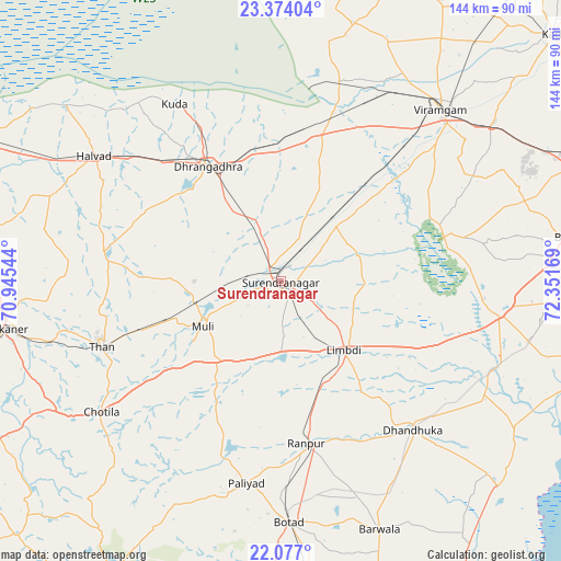
Surendranagar GPS coordinates[2]
22° 43' 37.416" North, 71° 38' 54.816" East
| Map corner | latitude | longitude |
|---|---|---|
| Upper-left | 23.37404°, | 70.94544° |
| Center: | 22.72706°, | 71.64856° |
| Lower-right: | 22.077°, | 72.35169° |
| Map W x H: | 144.2×144.2 km | = 89.6×89.6mi |
| max Lat: | 34.9274° ⇑50.6% North |
| Surendranagar: | 22.72706° |
| min Lat: | ⇓49.4% South 8.09008° |
| min Long | Surendranagar | max Long |
| 68.82655° | 71.64856° | 96.81° |
| W 2.2%⇐ | ⇒97.8% E |
Elevation
Elevation of Surendranagar is 68 m = 223 ft, and this is 227.6 m = 747 ft below average elevation for this country.
| Max E: |
3681 m = 12077 ft | 75% |
| Avg. | 295.6 m = 970 ft | |
| Surendranagar | 68 m = 223 ft | |
Min E: |
1 m = 3 ft | 25% |
See also: Surendranagar elevation on elevation.city.
Geographical zone
Surendranagar is located in North Torrid zone (between Equator and Tropic of Cancer). Distance of this Northern Tropic circle is 78.9 km =49 mi to North.| Distance of | km | miles | from Surendranagar |
|---|---|---|---|
| North Pole | 7480 | 4647.9 | to North |
| Arctic Circle | 4874.2 | 3028.7 | to North |
| Tropic Cancer | 78.9 | 49 | to North |
| Equator | 2527 | 1570.2 | to South |


Nearby cities:
15 places around Surendranagar: (largest is in red/bold)
• Botād
62.1 km =38.6 mi,  178°
178°
• Chotila
57.4 km =35.7 mi,  233°
233°
• Dhandhuka
51.8 km =32.2 mi,  137°
137°
• Dholka
81.3 km =50.5 mi,  89°
89°
• Dhrāngadhra
34.8 km =21.6 mi,  327°
327°
• Halvad
57.7 km =35.9 mi,  303°
303°
• Lakhtar
20.3 km =12.6 mi,  44°
44°
• Limbdi
24.5 km =15.2 mi, 137°
• Māndal
68.3 km =42.4 mi,  23°
23°
• Pāliyād
53 km =32.9 mi,  189°
189°
• Sānand
80.7 km =50.1 mi,  68°
68°
• Sāyla
26.1 km =16.2 mi,  220°
220°
• Thān
49.1 km =30.5 mi,  249°
249°
• Vinchia
63.8 km =39.6 mi,  205°
205°
• Wānkāner
73.4 km =45.6 mi,  259°
259°
Sources, notices
• [Note1] Compared only with cities in India existing in our database
• [Src1] Map data: © OpenStreetMap contributors (CC-BY-SA)
• [Src2] Other city data from geonames.org with taken over terms of usage.
• [Src3] Geographical zone / Annual Mean Temperature by Robert A. Rohde @ Wikipedia
