Lakhtar geodata
Lakhtar (Gujarat) is a populated place; located in India in Asia/Kolkata (GMT+5.5) time zone. With population of 14,534 people, there are 2507 cities with bigger population in this country. Compared to other cities in India, 50.6% of cities are located further ↓South; 97.7% of cities are located further →East and 79.7% of cities have higher elevation than Lakhtar. Note1


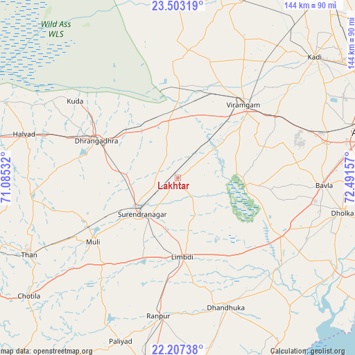
Lakhtar GPS coordinates[2]
22° 51' 24.588" North, 71° 47' 18.384" East
| Map corner | latitude | longitude |
|---|---|---|
| Upper-left | 23.50319°, | 71.08532° |
| Center: | 22.85683°, | 71.78844° |
| Lower-right: | 22.20738°, | 72.49157° |
| Map W x H: | 144.1×144.1 km | = 89.5×89.5mi |
| max Lat: | 34.9274° ⇑49.4% North |
| Lakhtar: | 22.85683° |
| min Lat: | ⇓50.6% South 8.09008° |
| min Long | Lakhtar | max Long |
| 68.82655° | 71.78844° | 96.81° |
| W 2.3%⇐ | ⇒97.7% E |
Elevation
Elevation of Lakhtar is 49 m = 161 ft, and this is 246.6 m = 809 ft below average elevation for this country.
| Max E: |
3681 m = 12077 ft | 79.7% |
| Avg. | 295.6 m = 970 ft | |
| Lakhtar | 49 m = 161 ft | |
Min E: |
1 m = 3 ft | 20.3% |
See also: India elevation on elevation.city.
Geographical zone
Lakhtar is located in North Torrid zone (between Equator and Tropic of Cancer). Distance of this Northern Tropic circle is 64.5 km =40.1 mi to North.| Distance of | km | miles | from Lakhtar |
|---|---|---|---|
| North Pole | 7465.6 | 4638.9 | to North |
| Arctic Circle | 4859.7 | 3019.7 | to North |
| Tropic Cancer | 64.5 | 40.1 | to North |
| Equator | 2541.4 | 1579.2 | to South |


Nearby cities:
15 places around Lakhtar: (largest is in red/bold)
• Botād
77.5 km =48.2 mi,  189°
189°
• Chotila
77.5 km =48.2 mi,  231°
231°
• Dhandhuka
56.6 km =35.2 mi,  158°
158°
• Dholka
68.5 km =42.6 mi,  102°
102°
• Dhrāngadhra
36.1 km =22.4 mi,  294°
294°
• Halvad
64.7 km =40.2 mi, 285°
• Kadi
74.4 km =46.2 mi,  48°
48°
• Limbdi
32.5 km =20.2 mi,  175°
175°
• Māndal
49.8 km =30.9 mi,  15°
15°
• Pāliyād
70.6 km =43.9 mi,  199°
199°
• Sarkhej
74.4 km =46.2 mi,  79°
79°
• Surendranagar
20.3 km =12.6 mi,  224°
224°
• Sānand
62.6 km =38.9 mi, 76°
• Sāyla
46.4 km =28.8 mi, 222°
• Thān
68.1 km =42.3 mi,  242°
242°
Sources, notices
• [Note1] Compared only with cities in India existing in our database
• [Src1] Map data: © OpenStreetMap contributors (CC-BY-SA)
• [Src2] Other city data from geonames.org with taken over terms of usage.
• [Src3] Geographical zone / Annual Mean Temperature by Robert A. Rohde @ Wikipedia
