Un geodata
Un (Gujarat) is a populated place; located in India in Asia/Kolkata (GMT+5.5) time zone. With population of 30,671 people, there are 1415 cities with bigger population in this country. Compared to other cities in India, 57.6% of cities are located further ↓South; 97.7% of cities are located further →East and 79.7% of cities have higher elevation than Un. Note1


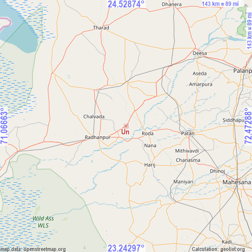
Un GPS coordinates[2]
23° 53' 14.82" North, 71° 46' 11.1" East
| Map corner | latitude | longitude |
|---|---|---|
| Upper-left | 24.52874°, | 71.06663° |
| Center: | 23.88745°, | 71.76975° |
| Lower-right: | 23.24297°, | 72.47288° |
| Map W x H: | 143×143 km | = 88.9×88.9mi |
| max Lat: | 34.9274° ⇑42.4% North |
| Un: | 23.88745° |
| min Lat: | ⇓57.6% South 8.09008° |
| min Long | Un | max Long |
| 68.82655° | 71.76975° | 96.81° |
| W 2.3%⇐ | ⇒97.7% E |
Elevation
Elevation of Un is 49 m = 161 ft, and this is 246.6 m = 809 ft below average elevation for this country.
| Max E: |
3681 m = 12077 ft | 79.7% |
| Avg. | 295.6 m = 970 ft | |
| Un | 49 m = 161 ft | |
Min E: |
1 m = 3 ft | 20.3% |
See also: India elevation on elevation.city.
Geographical zone
Un is located in North temperate zone (between Tropic of Cancer and the Arctic Circle). Distance of this Northern Tropic circle is 50.1 km =31.1 mi to South.| Distance of | km | miles | from Un |
|---|---|---|---|
| North Pole | 7351 | 4567.7 | to North |
| Arctic Circle | 4745.1 | 2948.5 | to North |
| Tropic Cancer | 50.1 | 31.1 | to South |
| Equator | 2656 | 1650.4 | to South |


Nearby cities:
15 places around Un: (largest is in red/bold)
• Chānasma
39.8 km =24.7 mi,  118°
118°
• Dhanera
73.8 km =45.9 mi,  20°
20°
• Dīsa
58.4 km =36.3 mi,  45°
45°
• Hārij
25.7 km =16 mi,  147°
147°
• Kadi
87.1 km =54.1 mi,  138°
138°
• Kherālu
86.3 km =53.6 mi,  90°
90°
• Kānodar
67.2 km =41.8 mi,  70°
70°
• Māndal
68.3 km =42.4 mi,  167°
167°
• Pālanpur
74.9 km =46.5 mi, 65°
• Pātan
36.8 km =22.9 mi,  96°
96°
• Rādhanpur
17.9 km =11.1 mi,  249°
249°
• Siddhapur
61.3 km =38.1 mi, 86°
• Tharād
58.4 km =36.3 mi,  345°
345°
• Unjha
63.9 km =39.7 mi, 98°
• Visnagar
82.3 km =51.1 mi, 104°
Sources, notices
• [Note1] Compared only with cities in India existing in our database
• [Src1] Map data: © OpenStreetMap contributors (CC-BY-SA)
• [Src2] Other city data from geonames.org with taken over terms of usage.
• [Src3] Geographical zone / Annual Mean Temperature by Robert A. Rohde @ Wikipedia
