Dhrāngadhra geodata
Dhrāngadhra (Gujarat) is a populated place; located in India in Asia/Kolkata (GMT+5.5) time zone. With population of 75,578 people, there are 583 cities with bigger population in this country. Compared to other cities in India, 51.6% of cities are located further ↓South; 98.1% of cities are located further →East and 79.2% of cities have higher elevation than Dhrāngadhra. Note1


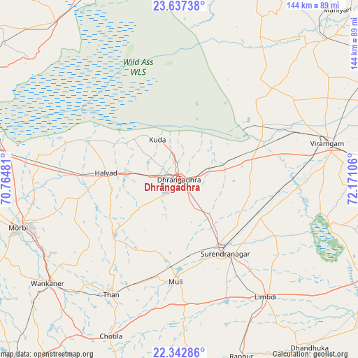
Dhrāngadhra GPS coordinates[2]
22° 59' 30.012" North, 71° 28' 4.548" East
| Map corner | latitude | longitude |
|---|---|---|
| Upper-left | 23.63738°, | 70.76481° |
| Center: | 22.99167°, | 71.46793° |
| Lower-right: | 22.34286°, | 72.17106° |
| Map W x H: | 143.9×143.9 km | = 89.4×89.4mi |
| max Lat: | 34.9274° ⇑48.4% North |
| Dhrāngadhra: | 22.99167° |
| min Lat: | ⇓51.6% South 8.09008° |
| min Long | Dhrāngadhra | max Long |
| 68.82655° | 71.46793° | 96.81° |
| W 1.9%⇐ | ⇒98.1% E |
Elevation
Elevation of Dhrāngadhra is 51 m = 167 ft, and this is 244.6 m = 802 ft below average elevation for this country.
| Max E: |
3681 m = 12077 ft | 79.2% |
| Avg. | 295.6 m = 970 ft | |
| Dhrāngadhra | 51 m = 167 ft | |
Min E: |
1 m = 3 ft | 20.8% |
See also: Dhrāngadhra elevation on elevation.city.
Geographical zone
Dhrāngadhra is located in North Torrid zone (between Equator and Tropic of Cancer). Distance of this Northern Tropic circle is 49.5 km =30.8 mi to North.| Distance of | km | miles | from Dhrāngadhra |
|---|---|---|---|
| North Pole | 7450.6 | 4629.6 | to North |
| Arctic Circle | 4844.7 | 3010.4 | to North |
| Tropic Cancer | 49.5 | 30.8 | to North |
| Equator | 2556.4 | 1588.5 | to South |


Nearby cities:
15 places around Dhrāngadhra: (largest is in red/bold)
• Chotila
69 km =42.9 mi,  203°
203°
• Dhandhuka
86.2 km =53.6 mi,  141°
141°
• Halvad
29.6 km =18.4 mi,  275°
275°
• Hārij
90 km =55.9 mi,  29°
29°
• Lakhtar
36.1 km =22.4 mi,  114°
114°
• Limbdi
59 km =36.7 mi, 143°
• Morbi
67.4 km =41.9 mi,  253°
253°
• Māndal
56.7 km =35.2 mi,  54°
54°
• Pāliyād
82.2 km =51.1 mi,  173°
173°
• Surendranagar
34.8 km =21.6 mi,  147°
147°
• Sāyla
49.2 km =30.6 mi,  178°
178°
• Tankāra
82.5 km =51.3 mi,  243°
243°
• Thān
54 km =33.6 mi,  210°
210°
• Vinchia
87.4 km =54.3 mi,  185°
185°
• Wānkāner
68.3 km =42.4 mi,  231°
231°
Sources, notices
• [Note1] Compared only with cities in India existing in our database
• [Src1] Map data: © OpenStreetMap contributors (CC-BY-SA)
• [Src2] Other city data from geonames.org with taken over terms of usage.
• [Src3] Geographical zone / Annual Mean Temperature by Robert A. Rohde @ Wikipedia
