Hārij geodata
Hārij (Gujarat) is a populated place; located in India in Asia/Kolkata (GMT+5.5) time zone. With population of 18,964 people, there are 2130 cities with bigger population in this country. Compared to other cities in India, 56% of cities are located further ↓South; 97.5% of cities are located further →East and 79.4% of cities have higher elevation than Hārij. Note1


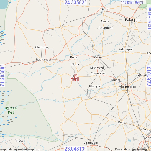
Hārij GPS coordinates[2]
23° 41' 36.816" North, 71° 54' 25.2" East
| Map corner | latitude | longitude |
|---|---|---|
| Upper-left | 24.33582°, | 71.20388° |
| Center: | 23.69356°, | 71.907° |
| Lower-right: | 23.04813°, | 72.61013° |
| Map W x H: | 143.2×143.2 km | = 89×89mi |
| max Lat: | 34.9274° ⇑44% North |
| Hārij: | 23.69356° |
| min Lat: | ⇓56% South 8.09008° |
| min Long | Hārij | max Long |
| 68.82655° | 71.907° | 96.81° |
| W 2.5%⇐ | ⇒97.5% E |
Elevation
Elevation of Hārij is 50 m = 164 ft, and this is 245.6 m = 806 ft below average elevation for this country.
| Max E: |
3681 m = 12077 ft | 79.4% |
| Avg. | 295.6 m = 970 ft | |
| Hārij | 50 m = 164 ft | |
Min E: |
1 m = 3 ft | 20.6% |
See also: India elevation on elevation.city.
Geographical zone
Hārij is located in North temperate zone (between Tropic of Cancer and the Arctic Circle). Distance of this Northern Tropic circle is 28.6 km =17.8 mi to South.| Distance of | km | miles | from Hārij |
|---|---|---|---|
| North Pole | 7372.6 | 4581.1 | to North |
| Arctic Circle | 4766.7 | 2961.9 | to North |
| Tropic Cancer | 28.6 | 17.8 | to South |
| Equator | 2634.5 | 1637 | to South |


Nearby cities:
15 places around Hārij: (largest is in red/bold)
• Chānasma
21.1 km =13.1 mi,  83°
83°
• Dīsa
68.4 km =42.5 mi,  23°
23°
• Jhulasan
70.6 km =43.9 mi,  125°
125°
• Kadi
61.8 km =38.4 mi,  135°
135°
• Kherālu
75.5 km =46.9 mi,  73°
73°
• Kānodar
66.2 km =41.1 mi,  48°
48°
• Māndal
45 km =28 mi,  178°
178°
• Pālanpur
75.7 km =47 mi, 45°
• Pātan
28.6 km =17.8 mi, 52°
• Rādhanpur
34.4 km =21.4 mi,  296°
296°
• Siddhapur
53.5 km =33.2 mi,  62°
62°
• Un
25.7 km =16 mi,  327°
327°
• Unjha
50.8 km =31.6 mi, 76°
• Vadnagar
75.2 km =46.7 mi, 82°
• Visnagar
65.7 km =40.8 mi,  89°
89°
Sources, notices
• [Note1] Compared only with cities in India existing in our database
• [Src1] Map data: © OpenStreetMap contributors (CC-BY-SA)
• [Src2] Other city data from geonames.org with taken over terms of usage.
• [Src3] Geographical zone / Annual Mean Temperature by Robert A. Rohde @ Wikipedia
