Farīdkot geodata
Farīdkot (Punjab) is a populated place; located in India in Asia/Kolkata (GMT+5.5) time zone. With population of 77,450 people, there are 563 cities with bigger population in this country. Compared to other cities in India, 94.7% of cities are located further ↓South; 84.8% of cities are located further →East and 50.9% of cities have lower elevation than Farīdkot. Note1


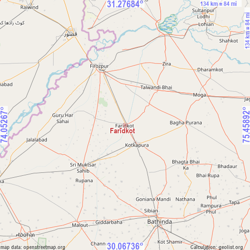
Farīdkot GPS coordinates[2]
30° 40' 26.364" North, 74° 45' 20.844" East
| Map corner | latitude | longitude |
|---|---|---|
| Upper-left | 31.27684°, | 74.05267° |
| Center: | 30.67399°, | 74.75579° |
| Lower-right: | 30.06736°, | 75.45892° |
| Map W x H: | 134.5×134.5 km | = 83.6×83.6mi |
| max Lat: | 34.9274° ⇑5.3% North |
| Farīdkot: | 30.67399° |
| min Lat: | ⇓94.7% South 8.09008° |
| min Long | Farīdkot | max Long |
| 68.82655° | 74.75579° | 96.81° |
| W 15.2%⇐ | ⇒84.8% E |
Elevation
Elevation of Farīdkot is 207 m = 679 ft, and this is 88.6 m = 291 ft below average elevation for this country.
| Max E: |
3681 m = 12077 ft | 49.1% |
| Avg. | 295.6 m = 970 ft | |
| Farīdkot | 207 m = 679 ft | |
Min E: |
1 m = 3 ft | 50.9% |
See also: Farīdkot elevation on elevation.city.
Geographical zone
Farīdkot is located in North temperate zone (between Tropic of Cancer and the Arctic Circle). Distance of this Northern Tropic circle is 804.7 km =500 mi to South.| Distance of | km | miles | from Farīdkot |
|---|---|---|---|
| North Pole | 6596.4 | 4098.8 | to North |
| Arctic Circle | 3990.5 | 2479.6 | to North |
| Tropic Cancer | 804.7 | 500 | to South |
| Equator | 3410.6 | 2119.2 | to South |


Nearby cities:
15 places around Farīdkot: (largest is in red/bold)
• Badhni Kalān
51.2 km =31.8 mi,  89°
89°
• Bathinda
54.8 km =34.1 mi,  161°
161°
• Bāgha Purāna
32.8 km =20.4 mi, 87°
• Ferozepore
31.1 km =19.3 mi,  334°
334°
• Giddarbāha
53.4 km =33.2 mi,  189°
189°
• Guru Har Sahāi
33.8 km =21 mi,  276°
276°
• Jaito
28 km =17.4 mi,  152°
152°
• Jalālābād
48.3 km =30 mi,  261°
261°
• Kot Īsa Khān
47.4 km =29.5 mi,  50°
50°
• Kotkapura
12.6 km =7.8 mi,  144°
144°
• Makhu
53 km =32.9 mi,  25°
25°
• Moga
42.4 km =26.3 mi,  68°
68°
• Muktsar
31.9 km =19.8 mi,  225°
225°
• Talwandi Bhai
26.2 km =16.3 mi,  39°
39°
• Zira
39.7 km =24.7 mi, 34°
Sources, notices
• [Note1] Compared only with cities in India existing in our database
• [Src1] Map data: © OpenStreetMap contributors (CC-BY-SA)
• [Src2] Other city data from geonames.org with taken over terms of usage.
• [Src3] Geographical zone / Annual Mean Temperature by Robert A. Rohde @ Wikipedia
