Jalālābād geodata
Jalālābād (Punjab) is a populated place; located in India in Asia/Kolkata (GMT+5.5) time zone. With population of 29,824 people, there are 1454 cities with bigger population in this country. Compared to other cities in India, 94.6% of cities are located further ↓South; 88.1% of cities are located further →East and 52.2% of cities have higher elevation than Jalālābād. Note1


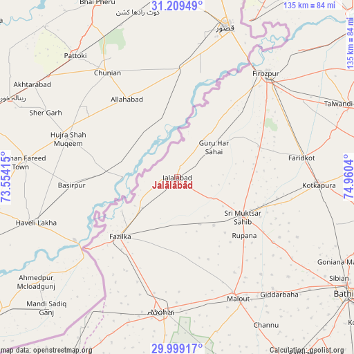
Jalālābād GPS coordinates[2]
30° 36' 22.392" North, 74° 15' 26.172" East
| Map corner | latitude | longitude |
|---|---|---|
| Upper-left | 31.20949°, | 73.55415° |
| Center: | 30.60622°, | 74.25727° |
| Lower-right: | 29.99917°, | 74.9604° |
| Map W x H: | 134.6×134.6 km | = 83.6×83.6mi |
| max Lat: | 34.9274° ⇑5.4% North |
| Jalālābād: | 30.60622° |
| min Lat: | ⇓94.6% South 8.09008° |
| min Long | Jalālābād | max Long |
| 68.82655° | 74.25727° | 96.81° |
| W 11.9%⇐ | ⇒88.1% E |
Elevation
Elevation of Jalālābād is 189 m = 620 ft, and this is 106.6 m = 350 ft below average elevation for this country.
| Max E: |
3681 m = 12077 ft | 52.2% |
| Avg. | 295.6 m = 970 ft | |
| Jalālābād | 189 m = 620 ft | |
Min E: |
1 m = 3 ft | 47.8% |
See also: India elevation on elevation.city.
Geographical zone
Jalālābād is located in North temperate zone (between Tropic of Cancer and the Arctic Circle). Distance of this Northern Tropic circle is 797.2 km =495.4 mi to South.| Distance of | km | miles | from Jalālābād |
|---|---|---|---|
| North Pole | 6604 | 4103.5 | to North |
| Arctic Circle | 3998.1 | 2484.3 | to North |
| Tropic Cancer | 797.2 | 495.4 | to South |
| Equator | 3403.1 | 2114.6 | to South |


Nearby cities:
15 places around Jalālābād: (largest is in red/bold)
• Abohar
51.7 km =32.1 mi,  186°
186°
• Bathinda
79 km =49.1 mi,  124°
124°
• Bāgha Purāna
81 km =50.3 mi,  83°
83°
• Farīdkot
48.3 km =30 mi, 81°
• Ferozepore
49.2 km =30.6 mi,  43°
43°
• Fāzilka
31.6 km =19.6 mi,  224°
224°
• Giddarbāha
59.9 km =37.2 mi,  139°
139°
• Guru Har Sahāi
18.1 km =11.2 mi,  50°
50°
• Jaito
63.2 km =39.3 mi,  105°
105°
• Khem Karan
66.4 km =41.3 mi,  25°
25°
• Kotkapura
55.2 km =34.3 mi,  92°
92°
• Malaut
48.9 km =30.4 mi,  153°
153°
• Muktsar
28.8 km =17.9 mi, 120°
• Talwandi Bhai
70 km =43.5 mi,  66°
66°
• Zira
80.8 km =50.2 mi,  60°
60°
Sources, notices
• [Note1] Compared only with cities in India existing in our database
• [Src1] Map data: © OpenStreetMap contributors (CC-BY-SA)
• [Src2] Other city data from geonames.org with taken over terms of usage.
• [Src3] Geographical zone / Annual Mean Temperature by Robert A. Rohde @ Wikipedia
