Fāzilka geodata
Fāzilka (Punjab) is a seat of a second-order administrative division; located in India in Asia/Kolkata (GMT+5.5) time zone. With population of 70,887 people, there are 616 cities with bigger population in this country. Compared to other cities in India, 94.1% of cities are located further ↓South; 89.2% of cities are located further →East and 53.8% of cities have higher elevation than Fāzilka. Note1


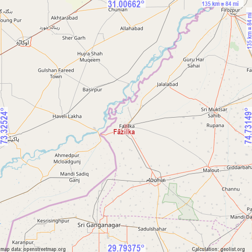
Fāzilka GPS coordinates[2]
30° 24' 7.452" North, 74° 1' 42.096" East
| Map corner | latitude | longitude |
|---|---|---|
| Upper-left | 31.00662°, | 73.32524° |
| Center: | 30.40207°, | 74.02836° |
| Lower-right: | 29.79375°, | 74.73149° |
| Map W x H: | 134.9×134.9 km | = 83.8×83.8mi |
| max Lat: | 34.9274° ⇑5.9% North |
| Fāzilka: | 30.40207° |
| min Lat: | ⇓94.1% South 8.09008° |
| min Long | Fāzilka | max Long |
| 68.82655° | 74.02836° | 96.81° |
| W 10.8%⇐ | ⇒89.2% E |
Elevation
Elevation of Fāzilka is 181 m = 594 ft, and this is 114.6 m = 376 ft below average elevation for this country.
| Max E: |
3681 m = 12077 ft | 53.8% |
| Avg. | 295.6 m = 970 ft | |
| Fāzilka | 181 m = 594 ft | |
Min E: |
1 m = 3 ft | 46.2% |
See also: Fāzilka elevation on elevation.city.
Geographical zone
Fāzilka is located in North temperate zone (between Tropic of Cancer and the Arctic Circle). Distance of this Northern Tropic circle is 774.5 km =481.3 mi to South.| Distance of | km | miles | from Fāzilka |
|---|---|---|---|
| North Pole | 6626.7 | 4117.6 | to North |
| Arctic Circle | 4020.8 | 2498.4 | to North |
| Tropic Cancer | 774.5 | 481.3 | to South |
| Equator | 3380.4 | 2100.5 | to South |


Nearby cities:
15 places around Fāzilka: (largest is in red/bold)
• Abohar
32.8 km =20.4 mi,  150°
150°
• Dabwāli
84.8 km =52.7 mi,  126°
126°
• Farīdkot
75.9 km =47.2 mi,  66°
66°
• Ferozepore
80.7 km =50.1 mi,  43°
43°
• Gangānagar
55.6 km =34.5 mi,  195°
195°
• Giddarbāha
65.2 km =40.5 mi,  110°
110°
• Guru Har Sahāi
49.6 km =30.8 mi,  46°
46°
• Jaito
83 km =51.6 mi,  86°
86°
• Jalālābād
31.6 km =19.6 mi, 44°
• Karanpur
83.3 km =51.8 mi,  221°
221°
• Kotkapura
79.6 km =49.5 mi,  75°
75°
• Malaut
48.4 km =30.1 mi,  115°
115°
• Muktsar
47.5 km =29.5 mi, 80°
• Padampur
86.3 km =53.6 mi,  206°
206°
• Sangariā
79.2 km =49.2 mi, 147°
Sources, notices
• [Note1] Compared only with cities in India existing in our database
• [Src1] Map data: © OpenStreetMap contributors (CC-BY-SA)
• [Src2] Other city data from geonames.org with taken over terms of usage.
• [Src3] Geographical zone / Annual Mean Temperature by Robert A. Rohde @ Wikipedia
