Guru Har Sahāi geodata
Guru Har Sahāi (Punjab) is a populated place; located in India in Asia/Kolkata (GMT+5.5) time zone. With population of 16,027 people, there are 2368 cities with bigger population in this country. Compared to other cities in India, 94.9% of cities are located further ↓South; 87.4% of cities are located further →East and 51.9% of cities have higher elevation than Guru Har Sahāi. Note1


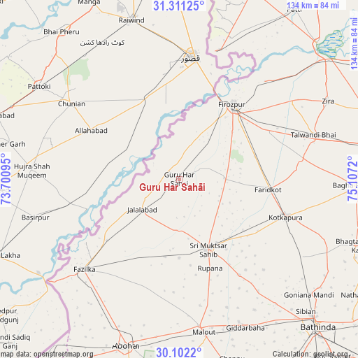
Guru Har Sahāi GPS coordinates[2]
30° 42' 31.032" North, 74° 24' 14.652" East
| Map corner | latitude | longitude |
|---|---|---|
| Upper-left | 31.31125°, | 73.70095° |
| Center: | 30.70862°, | 74.40407° |
| Lower-right: | 30.1022°, | 75.1072° |
| Map W x H: | 134.4×134.4 km | = 83.5×83.5mi |
| max Lat: | 34.9274° ⇑5.1% North |
| Guru Har Sahāi: | 30.70862° |
| min Lat: | ⇓94.9% South 8.09008° |
| min Long | Guru Har Sahāi | max Long |
| 68.82655° | 74.40407° | 96.81° |
| W 12.6%⇐ | ⇒87.4% E |
Elevation
Elevation of Guru Har Sahāi is 191 m = 627 ft, and this is 104.6 m = 343 ft below average elevation for this country.
| Max E: |
3681 m = 12077 ft | 51.9% |
| Avg. | 295.6 m = 970 ft | |
| Guru Har Sahāi | 191 m = 627 ft | |
Min E: |
1 m = 3 ft | 48.1% |
See also: India elevation on elevation.city.
Geographical zone
Guru Har Sahāi is located in North temperate zone (between Tropic of Cancer and the Arctic Circle). Distance of this Northern Tropic circle is 808.6 km =502.4 mi to South.| Distance of | km | miles | from Guru Har Sahāi |
|---|---|---|---|
| North Pole | 6592.6 | 4096.5 | to North |
| Arctic Circle | 3986.7 | 2477.2 | to North |
| Tropic Cancer | 808.6 | 502.4 | to South |
| Equator | 3414.5 | 2121.7 | to South |


Nearby cities:
15 places around Guru Har Sahāi: (largest is in red/bold)
• Abohar
65.8 km =40.9 mi,  197°
197°
• Bāgha Purāna
66.4 km =41.3 mi,  91°
91°
• Farīdkot
33.8 km =21 mi,  96°
96°
• Ferozepore
31.3 km =19.4 mi,  39°
39°
• Fāzilka
49.6 km =30.8 mi,  226°
226°
• Giddarbāha
61.9 km =38.5 mi,  156°
156°
• Jaito
54.8 km =34.1 mi,  121°
121°
• Jalālābād
18.1 km =11.2 mi, 230°
• Khem Karan
50.7 km =31.5 mi,  16°
16°
• Kotkapura
43.4 km =27 mi,  108°
108°
• Makhu
71.5 km =44.4 mi,  52°
52°
• Malaut
55.8 km =34.7 mi,  172°
172°
• Muktsar
28.2 km =17.5 mi, 157°
• Talwandi Bhai
52.8 km =32.8 mi,  71°
71°
• Zira
63.1 km =39.2 mi,  62°
62°
Sources, notices
• [Note1] Compared only with cities in India existing in our database
• [Src1] Map data: © OpenStreetMap contributors (CC-BY-SA)
• [Src2] Other city data from geonames.org with taken over terms of usage.
• [Src3] Geographical zone / Annual Mean Temperature by Robert A. Rohde @ Wikipedia
