Jaito geodata
Jaito (Punjab) is a populated place; located in India in Asia/Kolkata (GMT+5.5) time zone. With population of 34,346 people, there are 1268 cities with bigger population in this country. Compared to other cities in India, 94.2% of cities are located further ↓South; 83.6% of cities are located further →East and 51.6% of cities have lower elevation than Jaito. Note1


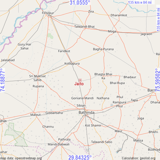
Jaito GPS coordinates[2]
30° 27' 4.536" North, 74° 53' 30.804" East
| Map corner | latitude | longitude |
|---|---|---|
| Upper-left | 31.0555°, | 74.18877° |
| Center: | 30.45126°, | 74.89189° |
| Lower-right: | 29.84325°, | 75.59502° |
| Map W x H: | 134.8×134.8 km | = 83.8×83.8mi |
| max Lat: | 34.9274° ⇑5.8% North |
| Jaito: | 30.45126° |
| min Lat: | ⇓94.2% South 8.09008° |
| min Long | Jaito | max Long |
| 68.82655° | 74.89189° | 96.81° |
| W 16.4%⇐ | ⇒83.6% E |
Elevation
Elevation of Jaito is 211 m = 692 ft, and this is 84.6 m = 278 ft below average elevation for this country.
| Max E: |
3681 m = 12077 ft | 48.4% |
| Avg. | 295.6 m = 970 ft | |
| Jaito | 211 m = 692 ft | |
Min E: |
1 m = 3 ft | 51.6% |
See also: India elevation on elevation.city.
Geographical zone
Jaito is located in North temperate zone (between Tropic of Cancer and the Arctic Circle). Distance of this Northern Tropic circle is 779.9 km =484.6 mi to South.| Distance of | km | miles | from Jaito |
|---|---|---|---|
| North Pole | 6621.2 | 4114.2 | to North |
| Arctic Circle | 4015.3 | 2495 | to North |
| Tropic Cancer | 779.9 | 484.6 | to South |
| Equator | 3385.9 | 2103.9 | to South |


Nearby cities:
15 places around Jaito: (largest is in red/bold)
• Badhni Kalān
46 km =28.6 mi,  56°
56°
• Bathinda
27.5 km =17.1 mi,  170°
170°
• Bhadaur
42.1 km =26.2 mi,  86°
86°
• Bāgha Purāna
32.9 km =20.4 mi,  36°
36°
• Dabwāli
57.8 km =35.9 mi,  194°
194°
• Farīdkot
28 km =17.4 mi,  332°
332°
• Giddarbāha
35.4 km =22 mi,  217°
217°
• Guru Har Sahāi
54.8 km =34.1 mi,  301°
301°
• Kotkapura
15.6 km =9.7 mi,  338°
338°
• Malaut
47.6 km =29.6 mi,  235°
235°
• Maur
53.4 km =33.2 mi,  139°
139°
• Moga
48.2 km =30 mi,  33°
33°
• Muktsar
36.1 km =22.4 mi,  274°
274°
• Rāmpura
39.9 km =24.8 mi,  122°
122°
• Talwandi Bhai
45.1 km =28 mi,  4°
4°
Sources, notices
• [Note1] Compared only with cities in India existing in our database
• [Src1] Map data: © OpenStreetMap contributors (CC-BY-SA)
• [Src2] Other city data from geonames.org with taken over terms of usage.
• [Src3] Geographical zone / Annual Mean Temperature by Robert A. Rohde @ Wikipedia
