Amānganj geodata
Amānganj (Madhya Pradesh) is a populated place; located in India in Asia/Kolkata (GMT+5.5) time zone. With population of 13,167 people, there are 2640 cities with bigger population in this country. Compared to other cities in India, 60.2% of cities are located further ↓South; 68% of cities are located further ←West and 68.8% of cities have lower elevation than Amānganj. Note1


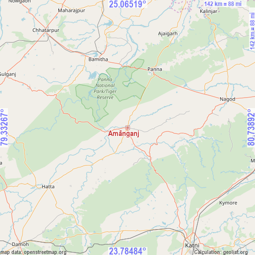
Amānganj GPS coordinates[2]
24° 25' 35.904" North, 80° 2' 8.844" East
| Map corner | latitude | longitude |
|---|---|---|
| Upper-left | 25.06519°, | 79.33267° |
| Center: | 24.42664°, | 80.03579° |
| Lower-right: | 23.78484°, | 80.73892° |
| Map W x H: | 142.4×142.4 km | = 88.5×88.5mi |
| max Lat: | 34.9274° ⇑39.8% North |
| Amānganj: | 24.42664° |
| min Lat: | ⇓60.2% South 8.09008° |
| min Long | Amānganj | max Long |
| 68.82655° | 80.03579° | 96.81° |
| W 68%⇐ | ⇒32% E |
Elevation
Elevation of Amānganj is 314 m = 1030 ft, and this is 18.4 m = 60 ft above average elevation for this country.
| Max E: |
3681 m = 12077 ft | 31.2% |
| Amānganj | 314 m 1030 ft | |
| Avg. | 295.6 m = 970 ft | |
Min E: |
1 m = 3 ft | 68.8% |
See also: India elevation on elevation.city.
Geographical zone
Amānganj is located in North temperate zone (between Tropic of Cancer and the Arctic Circle). Distance of this Northern Tropic circle is 110.1 km =68.4 mi to South.| Distance of | km | miles | from Amānganj |
|---|---|---|---|
| North Pole | 7291.1 | 4530.5 | to North |
| Arctic Circle | 4685.2 | 2911.2 | to North |
| Tropic Cancer | 110.1 | 68.4 | to South |
| Equator | 2716 | 1687.6 | to South |


Nearby cities:
15 places around Amānganj: (largest is in red/bold)
• Ajaigarh
57.1 km =35.5 mi,  23°
23°
• Bakshwāho
78.4 km =48.7 mi,  255°
255°
• Bijāwar
59.4 km =36.9 mi,  291°
291°
• Chandla
73.4 km =45.6 mi,  12°
12°
• Chhatarpur
70.9 km =44.1 mi,  320°
320°
• Hatta
54.8 km =34.1 mi,  233°
233°
• Hindoria
75 km =46.6 mi,  219°
219°
• Khajuraho Group of Monuments
48 km =29.8 mi,  347°
347°
• Maihar
75.6 km =47 mi,  103°
103°
• Murwāra
74.9 km =46.5 mi,  150°
150°
• Nāgod
58.1 km =36.1 mi,  74°
74°
• Panna
36.1 km =22.4 mi,  25°
25°
• Pawai
21.9 km =13.6 mi,  144°
144°
• Rājnagar
52.9 km =32.9 mi, 346°
• Satna
81.8 km =50.8 mi,  78°
78°
Sources, notices
• [Note1] Compared only with cities in India existing in our database
• [Src1] Map data: © OpenStreetMap contributors (CC-BY-SA)
• [Src2] Other city data from geonames.org with taken over terms of usage.
• [Src3] Geographical zone / Annual Mean Temperature by Robert A. Rohde @ Wikipedia
