Murwāra geodata
Murwāra (Madhya Pradesh) is a populated place; located in India in Asia/Kolkata (GMT+5.5) time zone. With population of 195,856 people, there are 219 cities with bigger population in this country. Compared to other cities in India, 57.2% of cities are located further ↓South; 70.7% of cities are located further ←West and 75% of cities have lower elevation than Murwāra. Note1


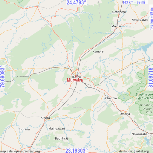
Murwāra GPS coordinates[2]
23° 50' 15.936" North, 80° 23' 38.58" East
| Map corner | latitude | longitude |
|---|---|---|
| Upper-left | 24.4793°, | 79.69093° |
| Center: | 23.83776°, | 80.39405° |
| Lower-right: | 23.19303°, | 81.09718° |
| Map W x H: | 143×143 km | = 88.9×88.9mi |
| max Lat: | 34.9274° ⇑42.8% North |
| Murwāra: | 23.83776° |
| min Lat: | ⇓57.2% South 8.09008° |
| min Long | Murwāra | max Long |
| 68.82655° | 80.39405° | 96.81° |
| W 70.7%⇐ | ⇒29.3% E |
Elevation
Elevation of Murwāra is 384 m = 1260 ft, and this is 88.4 m = 290 ft above average elevation for this country.
| Max E: |
3681 m = 12077 ft | 25% |
| Murwāra | 384 m 1260 ft | |
| Avg. | 295.6 m = 970 ft | |
Min E: |
1 m = 3 ft | 75% |
See also: Murwāra elevation on elevation.city.
Geographical zone
Murwāra is located in North temperate zone (between Tropic of Cancer and the Arctic Circle). Distance of this Northern Tropic circle is 44.6 km =27.7 mi to South.| Distance of | km | miles | from Murwāra |
|---|---|---|---|
| North Pole | 7356.6 | 4571.2 | to North |
| Arctic Circle | 4750.7 | 2951.9 | to North |
| Tropic Cancer | 44.6 | 27.7 | to South |
| Equator | 2650.5 | 1646.9 | to South |


Nearby cities:
15 places around Murwāra: (largest is in red/bold)
• Amarpātan
79.4 km =49.3 mi,  48°
48°
• Amānganj
74.9 km =46.5 mi,  330°
330°
• Barhi
43.4 km =27 mi,  80°
80°
• Chandia
37.9 km =23.5 mi,  122°
122°
• Hindoria
84.2 km =52.3 mi,  274°
274°
• Kaimori
83.2 km =51.7 mi,  232°
232°
• Katangi
75.2 km =46.7 mi, 234°
• Maihar
60.4 km =37.5 mi,  38°
38°
• Majholi
60.8 km =37.8 mi, 231°
• Nāgod
83.7 km =52 mi,  13°
13°
• Panāgar
73.7 km =45.8 mi,  213°
213°
• Pawai
53.2 km =33.1 mi, 333°
• Pāli
84.6 km =52.6 mi,  128°
128°
• Sihorā
48.9 km =30.4 mi,  217°
217°
• Umaria
57 km =35.4 mi, 127°
Sources, notices
• [Note1] Compared only with cities in India existing in our database
• [Src1] Map data: © OpenStreetMap contributors (CC-BY-SA)
• [Src2] Other city data from geonames.org with taken over terms of usage.
• [Src3] Geographical zone / Annual Mean Temperature by Robert A. Rohde @ Wikipedia
