Chandia geodata
Chandia (Madhya Pradesh) is a populated place; located in India in Asia/Kolkata (GMT+5.5) time zone. With population of 13,099 people, there are 2645 cities with bigger population in this country. Compared to other cities in India, 55.8% of cities are located further ↓South; 71.8% of cities are located further ←West and 76.7% of cities have lower elevation than Chandia. Note1


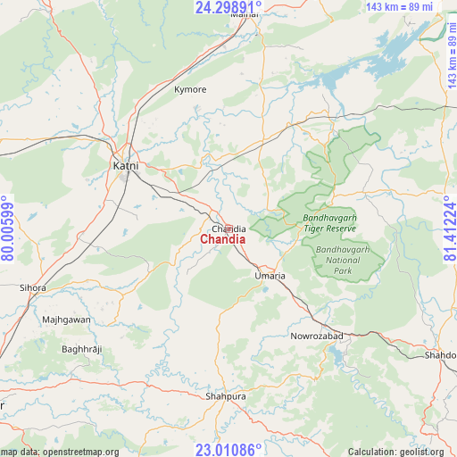
Chandia GPS coordinates[2]
23° 39' 23.292" North, 80° 42' 32.796" East
| Map corner | latitude | longitude |
|---|---|---|
| Upper-left | 24.29891°, | 80.00599° |
| Center: | 23.65647°, | 80.70911° |
| Lower-right: | 23.01086°, | 81.41224° |
| Map W x H: | 143.2×143.2 km | = 89×89mi |
| max Lat: | 34.9274° ⇑44.2% North |
| Chandia: | 23.65647° |
| min Lat: | ⇓55.8% South 8.09008° |
| min Long | Chandia | max Long |
| 68.82655° | 80.70911° | 96.81° |
| W 71.8%⇐ | ⇒28.2% E |
Elevation
Elevation of Chandia is 410 m = 1345 ft, and this is 114.4 m = 375 ft above average elevation for this country.
| Max E: |
3681 m = 12077 ft | 23.3% |
| Chandia | 410 m 1345 ft | |
| Avg. | 295.6 m = 970 ft | |
Min E: |
1 m = 3 ft | 76.7% |
See also: India elevation on elevation.city.
Geographical zone
Chandia is located in North temperate zone (between Tropic of Cancer and the Arctic Circle). Distance of this Northern Tropic circle is 24.4 km =15.2 mi to South.| Distance of | km | miles | from Chandia |
|---|---|---|---|
| North Pole | 7376.7 | 4583.7 | to North |
| Arctic Circle | 4770.8 | 2964.4 | to North |
| Tropic Cancer | 24.4 | 15.2 | to South |
| Equator | 2630.4 | 1634.5 | to South |


Nearby cities:
15 places around Chandia: (largest is in red/bold)
• Amarpātan
78 km =48.5 mi,  20°
20°
• Barhi
29.5 km =18.3 mi, 21°
• Beohāri
79.4 km =49.3 mi,  59°
59°
• Dindori
88.1 km =54.7 mi,  154°
154°
• Jaisinghnagar
69.5 km =43.2 mi,  87°
87°
• Maihar
68 km =42.3 mi,  4°
4°
• Majholi
81.9 km =50.9 mi,  257°
257°
• Murwāra
37.9 km =23.5 mi,  302°
302°
• Panāgar
83.7 km =52 mi,  240°
240°
• Pawai
87.7 km =54.5 mi,  320°
320°
• Pāli
47.1 km =29.3 mi,  133°
133°
• Shahdol
77.8 km =48.3 mi,  121°
121°
• Shāhpur
76.4 km =47.5 mi,  156°
156°
• Sihorā
64.5 km =40.1 mi,  253°
253°
• Umaria
19.6 km =12.2 mi,  138°
138°
Sources, notices
• [Note1] Compared only with cities in India existing in our database
• [Src1] Map data: © OpenStreetMap contributors (CC-BY-SA)
• [Src2] Other city data from geonames.org with taken over terms of usage.
• [Src3] Geographical zone / Annual Mean Temperature by Robert A. Rohde @ Wikipedia
