Koratla geodata
Koratla (Telangana) is a populated place; located in India in Asia/Kolkata (GMT+5.5) time zone. With population of 60,231 people, there are 727 cities with bigger population in this country. Compared to other cities in India, 69.2% of cities are located further ↑North; 55.9% of cities are located further ←West and 67% of cities have lower elevation than Koratla. Note1


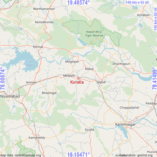
Koratla GPS coordinates[2]
18° 49' 17.544" North, 78° 42' 42.696" East
| Map corner | latitude | longitude |
|---|---|---|
| Upper-left | 19.48574°, | 78.00874° |
| Center: | 18.82154°, | 78.71186° |
| Lower-right: | 18.15471°, | 79.41499° |
| Map W x H: | 148×148 km | = 92×92mi |
| max Lat: | 34.9274° ⇑69.2% North |
| Koratla: | 18.82154° |
| min Lat: | ⇓30.8% South 8.09008° |
| min Long | Koratla | max Long |
| 68.82655° | 78.71186° | 96.81° |
| W 55.9%⇐ | ⇒44.1% E |
Elevation
Elevation of Koratla is 301 m = 988 ft, and this is 5.4 m = 18 ft above average elevation for this country.
| Max E: |
3681 m = 12077 ft | 33% |
| Koratla | 301 m 988 ft | |
| Avg. | 295.6 m = 970 ft | |
Min E: |
1 m = 3 ft | 67% |
See also: Koratla elevation on elevation.city.
Geographical zone
Koratla is located in North Torrid zone (between Equator and Tropic of Cancer). Distance of this Northern Tropic circle is 513.2 km =318.9 mi to North.| Distance of | km | miles | from Koratla |
|---|---|---|---|
| North Pole | 7914.3 | 4917.7 | to North |
| Arctic Circle | 5308.4 | 3298.5 | to North |
| Tropic Cancer | 513.2 | 318.9 | to North |
| Equator | 2092.8 | 1300.4 | to South |


Nearby cities:
15 places around Koratla: (largest is in red/bold)
• Jagtiāl
21.8 km =13.5 mi,  97°
97°
• Karīmnagar
61.1 km =38 mi,  134°
134°
• Kottapalli
54.2 km =33.7 mi, 131°
• Kāmāreddi
68.1 km =42.3 mi,  214°
214°
• Lakshettipet
53.4 km =33.2 mi,  84°
84°
• Mancherāl
75.6 km =47 mi,  85°
85°
• Nirmal
49.3 km =30.6 mi,  308°
308°
• Nizāmābād
66.7 km =41.4 mi,  255°
255°
• Nāspur
79 km =49.1 mi, 88°
• Peddapalli
73.5 km =45.7 mi,  108°
108°
• Ramagundam
80.6 km =50.1 mi, 95°
• Rāmgundam
77.9 km =48.4 mi, 91°
• Siddipet
81 km =50.3 mi,  169°
169°
• Sirsilla
49.2 km =30.6 mi, 167°
• Vemalwāda
42.9 km =26.7 mi,  157°
157°
Sources, notices
• [Note1] Compared only with cities in India existing in our database
• [Src1] Map data: © OpenStreetMap contributors (CC-BY-SA)
• [Src2] Other city data from geonames.org with taken over terms of usage.
• [Src3] Geographical zone / Annual Mean Temperature by Robert A. Rohde @ Wikipedia
