Jalārpet geodata
Jalārpet (Tamil Nadu) is a populated place; located in India in Asia/Kolkata (GMT+5.5) time zone. With population of 40,959 people, there are 1082 cities with bigger population in this country. Compared to other cities in India, 88.3% of cities are located further ↑North; 54.9% of cities are located further ←West and 76.9% of cities have lower elevation than Jalārpet. Note1


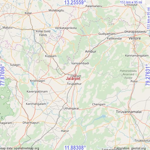
Jalārpet GPS coordinates[2]
12° 34' 12.9" North, 78° 34' 23.448" East
| Map corner | latitude | longitude |
|---|---|---|
| Upper-left | 13.25559°, | 77.87006° |
| Center: | 12.57025°, | 78.57318° |
| Lower-right: | 11.88308°, | 79.27631° |
| Map W x H: | 152.6×152.6 km | = 94.8×94.8mi |
| max Lat: | 34.9274° ⇑88.3% North |
| Jalārpet: | 12.57025° |
| min Lat: | ⇓11.7% South 8.09008° |
| min Long | Jalārpet | max Long |
| 68.82655° | 78.57318° | 96.81° |
| W 54.9%⇐ | ⇒45.1% E |
Elevation
Elevation of Jalārpet is 414 m = 1358 ft, and this is 118.4 m = 388 ft above average elevation for this country.
| Max E: |
3681 m = 12077 ft | 23.1% |
| Jalārpet | 414 m 1358 ft | |
| Avg. | 295.6 m = 970 ft | |
Min E: |
1 m = 3 ft | 76.9% |
See also: Jalārpet elevation on elevation.city.
Geographical zone
Jalārpet is located in North Torrid zone (between Equator and Tropic of Cancer). Distance of this Northern Tropic circle is 1208.2 km =750.7 mi to North.| Distance of | km | miles | from Jalārpet |
|---|---|---|---|
| North Pole | 8609.4 | 5349.6 | to North |
| Arctic Circle | 6003.5 | 3730.4 | to North |
| Tropic Cancer | 1208.2 | 750.7 | to North |
| Equator | 1397.7 | 868.5 | to South |


Nearby cities:
15 places around Jalārpet: (largest is in red/bold)
• Alangāyam
20.3 km =12.6 mi,  73°
73°
• Ambur
29.1 km =18.1 mi,  32°
32°
• Chengam
37.5 km =23.3 mi,  140°
140°
• Gudiyatham
53 km =32.9 mi,  37°
37°
• Harūr
58.4 km =36.3 mi,  189°
189°
• Krishnagiri
39.4 km =24.5 mi,  261°
261°
• Kunnattūr
25.7 km =16 mi,  195°
195°
• Kuppam
32 km =19.9 mi,  308°
308°
• Kāveripatnam
41.9 km =26 mi,  246°
246°
• Odugattūr
40.2 km =25 mi,  56°
56°
• Pallikondai
54.7 km =34 mi,  47°
47°
• Peranāmpattu
43.5 km =27 mi,  21°
21°
• Polūr
60.1 km =37.3 mi,  96°
96°
• Robertsonpet
53.7 km =33.4 mi,  323°
323°
• Vaniyambadi
13.4 km =8.3 mi, 22°
Sources, notices
• [Note1] Compared only with cities in India existing in our database
• [Src1] Map data: © OpenStreetMap contributors (CC-BY-SA)
• [Src2] Other city data from geonames.org with taken over terms of usage.
• [Src3] Geographical zone / Annual Mean Temperature by Robert A. Rohde @ Wikipedia
