Chengam geodata
Chengam (Tamil Nadu) is a populated place; located in India in Asia/Kolkata (GMT+5.5) time zone. With population of 23,904 people, there are 1776 cities with bigger population in this country. Compared to other cities in India, 88.9% of cities are located further ↑North; 56.9% of cities are located further ←West and 63.8% of cities have lower elevation than Chengam. Note1


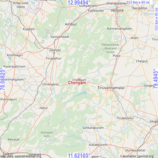
Chengam GPS coordinates[2]
12° 18' 32.004" North, 78° 47' 28.932" East
| Map corner | latitude | longitude |
|---|---|---|
| Upper-left | 12.99494°, | 78.08825° |
| Center: | 12.30889°, | 78.79137° |
| Lower-right: | 11.62105°, | 79.4945° |
| Map W x H: | 152.8×152.8 km | = 94.9×94.9mi |
| max Lat: | 34.9274° ⇑88.9% North |
| Chengam: | 12.30889° |
| min Lat: | ⇓11.1% South 8.09008° |
| min Long | Chengam | max Long |
| 68.82655° | 78.79137° | 96.81° |
| W 56.9%⇐ | ⇒43.1% E |
Elevation
Elevation of Chengam is 277 m = 909 ft, and this is 18.6 m = 61 ft below average elevation for this country.
| Max E: |
3681 m = 12077 ft | 36.2% |
| Avg. | 295.6 m = 970 ft | |
| Chengam | 277 m = 909 ft | |
Min E: |
1 m = 3 ft | 63.8% |
See also: India elevation on elevation.city.
Geographical zone
Chengam is located in North Torrid zone (between Equator and Tropic of Cancer). Distance of this Northern Tropic circle is 1237.3 km =768.8 mi to North.| Distance of | km | miles | from Chengam |
|---|---|---|---|
| North Pole | 8638.4 | 5367.7 | to North |
| Arctic Circle | 6032.6 | 3748.5 | to North |
| Tropic Cancer | 1237.3 | 768.8 | to North |
| Equator | 1368.6 | 850.4 | to South |


Nearby cities:
15 places around Chengam: (largest is in red/bold)
• Alagāpuram
48.9 km =30.4 mi,  163°
163°
• Alangāyam
35.1 km =21.8 mi,  353°
353°
• Ambur
54.3 km =33.7 mi, 351°
• Harūr
44.2 km =27.5 mi,  229°
229°
• Jalārpet
37.5 km =23.3 mi,  320°
320°
• Kunnattūr
30.8 km =19.1 mi,  278°
278°
• Manalūrpettai
46.8 km =29.1 mi,  135°
135°
• Odugattūr
52 km =32.3 mi,  11°
11°
• Pallippatti
59 km =36.7 mi, 225°
• Pennāthur
47.7 km =29.6 mi,  98°
98°
• Polūr
42.6 km =26.5 mi,  57°
57°
• Tirukkoyilur
58.7 km =36.5 mi,  130°
130°
• Tiruvannāmalai
32.1 km =19.9 mi,  106°
106°
• Vaniyambadi
45.4 km =28.2 mi,  335°
335°
• Vettavalam
54.2 km =33.7 mi, 114°
Sources, notices
• [Note1] Compared only with cities in India existing in our database
• [Src1] Map data: © OpenStreetMap contributors (CC-BY-SA)
• [Src2] Other city data from geonames.org with taken over terms of usage.
• [Src3] Geographical zone / Annual Mean Temperature by Robert A. Rohde @ Wikipedia
