Nādaun geodata
Nādaun (Himachal Pradesh) is a populated place; located in India in Asia/Kolkata (GMT+5.5) time zone. With population of 4,838 people, there are 3347 cities with bigger population in this country. Compared to other cities in India, 97.5% of cities are located further ↓South; 69.9% of cities are located further →East and 81.4% of cities have lower elevation than Nādaun. Note1


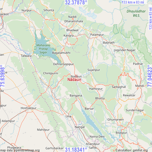
Nādaun GPS coordinates[2]
31° 46' 58.908" North, 76° 20' 35.16" East
| Map corner | latitude | longitude |
|---|---|---|
| Upper-left | 32.37878°, | 75.63998° |
| Center: | 31.78303°, | 76.3431° |
| Lower-right: | 31.18341°, | 77.04623° |
| Map W x H: | 132.9×132.9 km | = 82.6×82.6mi |
| max Lat: | 34.9274° ⇑2.5% North |
| Nādaun: | 31.78303° |
| min Lat: | ⇓97.5% South 8.09008° |
| min Long | Nādaun | max Long |
| 68.82655° | 76.3431° | 96.81° |
| W 30.1%⇐ | ⇒69.9% E |
Elevation
Elevation of Nādaun is 478 m = 1568 ft, and this is 182.4 m = 598 ft above average elevation for this country.
| Max E: |
3681 m = 12077 ft | 18.6% |
| Nādaun | 478 m 1568 ft | |
| Avg. | 295.6 m = 970 ft | |
Min E: |
1 m = 3 ft | 81.4% |
See also: India elevation on elevation.city.
Geographical zone
Nādaun is located in North temperate zone (between Tropic of Cancer and the Arctic Circle). Distance of this Northern Tropic circle is 928 km =576.6 mi to South.| Distance of | km | miles | from Nādaun |
|---|---|---|---|
| North Pole | 6473.1 | 4022.2 | to North |
| Arctic Circle | 3867.2 | 2403 | to North |
| Tropic Cancer | 928 | 576.6 | to South |
| Equator | 3533.9 | 2195.9 | to South |


Nearby cities:
15 places around Nādaun: (largest is in red/bold)
• Daulatpur
31.3 km =19.4 mi,  345°
345°
• Daulatpur
33.2 km =20.6 mi,  271°
271°
• Dera Gopipur
15.9 km =9.9 mi,  312°
312°
• Gagret
30 km =18.6 mi,  242°
242°
• Hamīrpur
20.4 km =12.7 mi,  122°
122°
• Jawāla Mukhi
10.4 km =6.5 mi, 347°
• Kāngar
35.1 km =21.8 mi, 347°
• Nagrota
38.6 km =24 mi,  322°
322°
• Nangal
43.8 km =27.2 mi,  175°
175°
• Pālampur
42 km =26.1 mi,  28°
28°
• Sarka Ghāt
38.2 km =23.7 mi,  104°
104°
• Talwāra
46.4 km =28.8 mi,  291°
291°
• Tīra Sujānpur
16.3 km =10.1 mi,  69°
69°
• Una
36.1 km =22.4 mi,  191°
191°
• Yol
44.6 km =27.7 mi,  341°
341°
Sources, notices
• [Note1] Compared only with cities in India existing in our database
• [Src1] Map data: © OpenStreetMap contributors (CC-BY-SA)
• [Src2] Other city data from geonames.org with taken over terms of usage.
• [Src3] Geographical zone / Annual Mean Temperature by Robert A. Rohde @ Wikipedia
