Ghumārwīn geodata
Ghumārwīn (Himachal Pradesh) is a populated place; located in India in Asia/Kolkata (GMT+5.5) time zone. With population of 6,690 people, there are 3235 cities with bigger population in this country. Compared to other cities in India, 96.8% of cities are located further ↓South; 66.2% of cities are located further →East and 90.5% of cities have lower elevation than Ghumārwīn. Note1


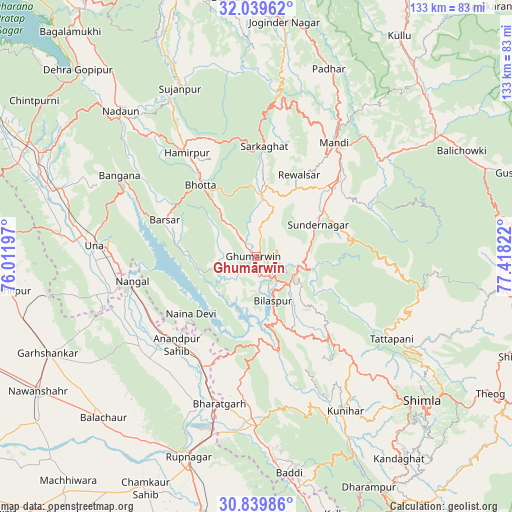
Ghumārwīn GPS coordinates[2]
31° 26' 29.976" North, 76° 42' 54.324" East
| Map corner | latitude | longitude |
|---|---|---|
| Upper-left | 32.03962°, | 76.01197° |
| Center: | 31.44166°, | 76.71509° |
| Lower-right: | 30.83986°, | 77.41822° |
| Map W x H: | 133.4×133.4 km | = 82.9×82.9mi |
| max Lat: | 34.9274° ⇑3.2% North |
| Ghumārwīn: | 31.44166° |
| min Lat: | ⇓96.8% South 8.09008° |
| min Long | Ghumārwīn | max Long |
| 68.82655° | 76.71509° | 96.81° |
| W 33.8%⇐ | ⇒66.2% E |
Elevation
Elevation of Ghumārwīn is 644 m = 2113 ft, and this is 348.4 m = 1143 ft above average elevation for this country.
| Max E: |
3681 m = 12077 ft | 9.5% |
| Ghumārwīn | 644 m 2113 ft | |
| Avg. | 295.6 m = 970 ft | |
Min E: |
1 m = 3 ft | 90.5% |
See also: India elevation on elevation.city.
Geographical zone
Ghumārwīn is located in North temperate zone (between Tropic of Cancer and the Arctic Circle). Distance of this Northern Tropic circle is 890.1 km =553.1 mi to South.| Distance of | km | miles | from Ghumārwīn |
|---|---|---|---|
| North Pole | 6511.1 | 4045.8 | to North |
| Arctic Circle | 3905.2 | 2426.6 | to North |
| Tropic Cancer | 890.1 | 553.1 | to South |
| Equator | 3496 | 2172.3 | to South |


Nearby cities:
15 places around Ghumārwīn: (largest is in red/bold)
• Anandpur
30.2 km =18.8 mi,  221°
221°
• Arki
40.1 km =24.9 mi,  143°
143°
• Bilaspur
13 km =8.1 mi,  162°
162°
• Hamīrpur
32.4 km =20.1 mi,  326°
326°
• Mandi
36.4 km =22.6 mi,  34°
34°
• Nangal
32.7 km =20.3 mi,  259°
259°
• Nālāgarh
44.5 km =27.7 mi,  179°
179°
• Nūrpur Kalān
37.7 km =23.4 mi, 215°
• Pāndoh
40.8 km =25.4 mi,  51°
51°
• Santokhgarh
39 km =24.2 mi, 255°
• Sarka Ghāt
28.7 km =17.8 mi,  3°
3°
• Seoni
44.7 km =27.8 mi,  119°
119°
• Sundarnagar
20.8 km =12.9 mi,  59°
59°
• Tīra Sujānpur
47.9 km =29.8 mi,  335°
335°
• Una
42.4 km =26.3 mi,  273°
273°
Sources, notices
• [Note1] Compared only with cities in India existing in our database
• [Src1] Map data: © OpenStreetMap contributors (CC-BY-SA)
• [Src2] Other city data from geonames.org with taken over terms of usage.
• [Src3] Geographical zone / Annual Mean Temperature by Robert A. Rohde @ Wikipedia
