Harihar geodata
Harihar (Karnataka) is a populated place; located in India in Asia/Kolkata (GMT+5.5) time zone. With population of 78,034 people, there are 559 cities with bigger population in this country. Compared to other cities in India, 82.4% of cities are located further ↑North; 75.6% of cities are located further →East and 84.6% of cities have lower elevation than Harihar. Note1


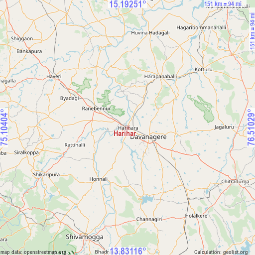
Harihar GPS coordinates[2]
14° 30' 46.368" North, 75° 48' 25.776" East
| Map corner | latitude | longitude |
|---|---|---|
| Upper-left | 15.19251°, | 75.10404° |
| Center: | 14.51288°, | 75.80716° |
| Lower-right: | 13.83116°, | 76.51029° |
| Map W x H: | 151.4×151.4 km | = 94.1×94.1mi |
| max Lat: | 34.9274° ⇑82.4% North |
| Harihar: | 14.51288° |
| min Lat: | ⇓17.6% South 8.09008° |
| min Long | Harihar | max Long |
| 68.82655° | 75.80716° | 96.81° |
| W 24.4%⇐ | ⇒75.6% E |
Elevation
Elevation of Harihar is 546 m = 1791 ft, and this is 250.4 m = 822 ft above average elevation for this country.
| Max E: |
3681 m = 12077 ft | 15.4% |
| Harihar | 546 m 1791 ft | |
| Avg. | 295.6 m = 970 ft | |
Min E: |
1 m = 3 ft | 84.6% |
See also: Harihar elevation on elevation.city.
Geographical zone
Harihar is located in North Torrid zone (between Equator and Tropic of Cancer). Distance of this Northern Tropic circle is 992.2 km =616.5 mi to North.| Distance of | km | miles | from Harihar |
|---|---|---|---|
| North Pole | 8393.4 | 5215.4 | to North |
| Arctic Circle | 5787.5 | 3596.2 | to North |
| Tropic Cancer | 992.2 | 616.5 | to North |
| Equator | 1613.7 | 1002.7 | to South |


Nearby cities:
15 places around Harihar: (largest is in red/bold)
• Byādgi
38.8 km =24.1 mi,  297°
297°
• Channagiri
55.8 km =34.7 mi,  166°
166°
• Davangere
13.9 km =8.6 mi,  111°
111°
• Hadagalli
58 km =36 mi,  13°
13°
• Harpanahalli
36.3 km =22.6 mi,  32°
32°
• Hirekerūr
44.8 km =27.8 mi,  261°
261°
• Holalkere
66.2 km =41.1 mi,  142°
142°
• Honnāli
35 km =21.7 mi,  209°
209°
• Hāveri
53.4 km =33.2 mi,  305°
305°
• Jagalūr
57.3 km =35.6 mi,  89°
89°
• Kottūru
56.3 km =35 mi,  52°
52°
• Māyakonda
38.8 km =24.1 mi,  129°
129°
• Nyāmti
47.5 km =29.5 mi, 211°
• Rānībennur
22.7 km =14.1 mi, 302°
• Shikārpur
55.6 km =34.5 mi,  240°
240°
Sources, notices
• [Note1] Compared only with cities in India existing in our database
• [Src1] Map data: © OpenStreetMap contributors (CC-BY-SA)
• [Src2] Other city data from geonames.org with taken over terms of usage.
• [Src3] Geographical zone / Annual Mean Temperature by Robert A. Rohde @ Wikipedia
