Jagalūr geodata
Jagalūr (Karnataka) is a populated place; located in India in Asia/Kolkata (GMT+5.5) time zone. With population of 15,787 people, there are 2392 cities with bigger population in this country. Compared to other cities in India, 82.3% of cities are located further ↑North; 70% of cities are located further →East and 91.8% of cities have lower elevation than Jagalūr. Note1


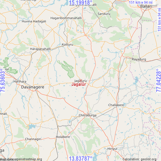
Jagalūr GPS coordinates[2]
14° 31' 10.452" North, 76° 20' 20.94" East
| Map corner | latitude | longitude |
|---|---|---|
| Upper-left | 15.19918°, | 75.63603° |
| Center: | 14.51957°, | 76.33915° |
| Lower-right: | 13.83787°, | 77.04228° |
| Map W x H: | 151.4×151.4 km | = 94.1×94.1mi |
| max Lat: | 34.9274° ⇑82.3% North |
| Jagalūr: | 14.51957° |
| min Lat: | ⇓17.7% South 8.09008° |
| min Long | Jagalūr | max Long |
| 68.82655° | 76.33915° | 96.81° |
| W 30%⇐ | ⇒70% E |
Elevation
Elevation of Jagalūr is 678 m = 2224 ft, and this is 382.4 m = 1255 ft above average elevation for this country.
| Max E: |
3681 m = 12077 ft | 8.2% |
| Jagalūr | 678 m 2224 ft | |
| Avg. | 295.6 m = 970 ft | |
Min E: |
1 m = 3 ft | 91.8% |
See also: India elevation on elevation.city.
Geographical zone
Jagalūr is located in North Torrid zone (between Equator and Tropic of Cancer). Distance of this Northern Tropic circle is 991.5 km =616.1 mi to North.| Distance of | km | miles | from Jagalūr |
|---|---|---|---|
| North Pole | 8392.6 | 5214.9 | to North |
| Arctic Circle | 5786.7 | 3595.7 | to North |
| Tropic Cancer | 991.5 | 616.1 | to North |
| Equator | 1614.4 | 1003.1 | to South |


Nearby cities:
15 places around Jagalūr: (largest is in red/bold)
• Challakere
40.4 km =25.1 mi,  123°
123°
• Channagiri
70.9 km =44.1 mi,  218°
218°
• Chitradurga
33.7 km =20.9 mi,  168°
168°
• Davangere
44.8 km =27.8 mi,  262°
262°
• Hadagalli
70.8 km =44 mi,  321°
321°
• Harihar
57.3 km =35.6 mi,  269°
269°
• Harpanahalli
48.1 km =29.9 mi,  308°
308°
• Hiriyūr
70.6 km =43.9 mi,  154°
154°
• Holalkere
55.5 km =34.5 mi,  197°
197°
• Kottūru
36.2 km =22.5 mi,  339°
339°
• Kūdligi
43.1 km =26.8 mi,  6°
6°
• Māyakonda
37.7 km =23.4 mi,  227°
227°
• Rānībennur
77.2 km =48 mi,  278°
278°
• Rāyadrug
58.7 km =36.5 mi,  70°
70°
• Sandūr
66.8 km =41.5 mi,  19°
19°
Sources, notices
• [Note1] Compared only with cities in India existing in our database
• [Src1] Map data: © OpenStreetMap contributors (CC-BY-SA)
• [Src2] Other city data from geonames.org with taken over terms of usage.
• [Src3] Geographical zone / Annual Mean Temperature by Robert A. Rohde @ Wikipedia
