Māyakonda geodata
Māyakonda (Karnataka) is a populated place; located in India in Asia/Kolkata (GMT+5.5) time zone. With population of 6,445 people, there are 3256 cities with bigger population in this country. Compared to other cities in India, 82.8% of cities are located further ↑North; 72.8% of cities are located further →East and 90.8% of cities have lower elevation than Māyakonda. Note1


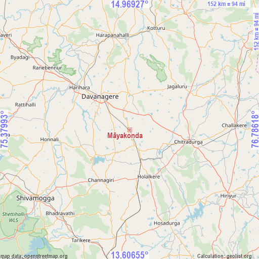
Māyakonda GPS coordinates[2]
14° 17' 20.184" North, 76° 4' 58.98" East
| Map corner | latitude | longitude |
|---|---|---|
| Upper-left | 14.96927°, | 75.37993° |
| Center: | 14.28894°, | 76.08305° |
| Lower-right: | 13.60655°, | 76.78618° |
| Map W x H: | 151.5×151.5 km | = 94.1×94.1mi |
| max Lat: | 34.9274° ⇑82.8% North |
| Māyakonda: | 14.28894° |
| min Lat: | ⇓17.2% South 8.09008° |
| min Long | Māyakonda | max Long |
| 68.82655° | 76.08305° | 96.81° |
| W 27.2%⇐ | ⇒72.8% E |
Elevation
Elevation of Māyakonda is 648 m = 2126 ft, and this is 352.4 m = 1156 ft above average elevation for this country.
| Max E: |
3681 m = 12077 ft | 9.2% |
| Māyakonda | 648 m 2126 ft | |
| Avg. | 295.6 m = 970 ft | |
Min E: |
1 m = 3 ft | 90.8% |
See also: India elevation on elevation.city.
Geographical zone
Māyakonda is located in North Torrid zone (between Equator and Tropic of Cancer). Distance of this Northern Tropic circle is 1017.1 km =632 mi to North.| Distance of | km | miles | from Māyakonda |
|---|---|---|---|
| North Pole | 8418.3 | 5230.9 | to North |
| Arctic Circle | 5812.4 | 3611.7 | to North |
| Tropic Cancer | 1017.1 | 632 | to North |
| Equator | 1588.8 | 987.2 | to South |


Nearby cities:
15 places around Māyakonda: (largest is in red/bold)
• Ajjampur
62.9 km =39.1 mi,  187°
187°
• Bhadrāvati
63.7 km =39.6 mi,  219°
219°
• Challakere
61.3 km =38.1 mi,  86°
86°
• Channagiri
34 km =21.1 mi,  209°
209°
• Chitradurga
35 km =21.7 mi,  102°
102°
• Davangere
26 km =16.2 mi,  319°
319°
• Harihar
38.8 km =24.1 mi,  309°
309°
• Harpanahalli
56.4 km =35 mi,  349°
349°
• Holalkere
29.5 km =18.3 mi,  158°
158°
• Honnāli
47.5 km =29.5 mi,  263°
263°
• Hosdurga
58.9 km =36.6 mi, 158°
• Jagalūr
37.7 km =23.4 mi,  47°
47°
• Kottūru
61.3 km =38.1 mi,  13°
13°
• Nyāmti
56.8 km =35.3 mi,  254°
254°
• Rānībennur
61.3 km =38.1 mi, 307°
Sources, notices
• [Note1] Compared only with cities in India existing in our database
• [Src1] Map data: © OpenStreetMap contributors (CC-BY-SA)
• [Src2] Other city data from geonames.org with taken over terms of usage.
• [Src3] Geographical zone / Annual Mean Temperature by Robert A. Rohde @ Wikipedia
