Korāput geodata
Korāput (Odisha) is a populated place; located in India in Asia/Kolkata (GMT+5.5) time zone. With population of 41,170 people, there are 1076 cities with bigger population in this country. Compared to other cities in India, 69.2% of cities are located further ↑North; 78.5% of cities are located further ←West and 95% of cities have lower elevation than Korāput. Note1


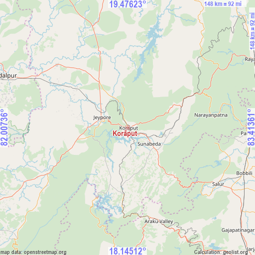
Korāput GPS coordinates[2]
18° 48' 43.164" North, 82° 42' 37.728" East
| Map corner | latitude | longitude |
|---|---|---|
| Upper-left | 19.47623°, | 82.00736° |
| Center: | 18.81199°, | 82.71048° |
| Lower-right: | 18.14512°, | 83.41361° |
| Map W x H: | 148×148 km | = 92×92mi |
| max Lat: | 34.9274° ⇑69.2% North |
| Korāput: | 18.81199° |
| min Lat: | ⇓30.8% South 8.09008° |
| min Long | Korāput | max Long |
| 68.82655° | 82.71048° | 96.81° |
| W 78.5%⇐ | ⇒21.5% E |
Elevation
Elevation of Korāput is 883 m = 2897 ft, and this is 587.4 m = 1927 ft above average elevation for this country.
| Max E: |
3681 m = 12077 ft | 5% |
| Korāput | 883 m 2897 ft | |
| Avg. | 295.6 m = 970 ft | |
Min E: |
1 m = 3 ft | 95% |
See also: Korāput elevation on elevation.city.
Geographical zone
Korāput is located in North Torrid zone (between Equator and Tropic of Cancer). Distance of this Northern Tropic circle is 514.2 km =319.5 mi to North.| Distance of | km | miles | from Korāput |
|---|---|---|---|
| North Pole | 7915.4 | 4918.4 | to North |
| Arctic Circle | 5309.5 | 3299.2 | to North |
| Tropic Cancer | 514.2 | 319.5 | to North |
| Equator | 2091.7 | 1299.7 | to South |


Nearby cities:
15 places around Korāput: (largest is in red/bold)
• Balimila
89.1 km =55.4 mi,  225°
225°
• Bobbili
73.3 km =45.5 mi,  111°
111°
• Chittarkonda
99.3 km =61.7 mi,  219°
219°
• Chīpurupalle
106.2 km =66 mi,  121°
121°
• Jagdalpur
78.4 km =48.7 mi,  292°
292°
• Jeypore
15.4 km =9.6 mi, 288°
• Kotapārh
54.7 km =34 mi,  312°
312°
• Malakanagiri
100 km =62.1 mi,  240°
240°
• Mādugula
100.3 km =62.3 mi,  173°
173°
• Nowrangapur
49.6 km =30.8 mi,  339°
339°
• Pārvatipuram
75.3 km =46.8 mi,  92°
92°
• Rāzām
107.8 km =67 mi, 111°
• Sālūr
61.6 km =38.3 mi, 122°
• Umarkot
108.6 km =67.5 mi,  330°
330°
• Vizianagaram
107 km =66.5 mi,  136°
136°
Sources, notices
• [Note1] Compared only with cities in India existing in our database
• [Src1] Map data: © OpenStreetMap contributors (CC-BY-SA)
• [Src2] Other city data from geonames.org with taken over terms of usage.
• [Src3] Geographical zone / Annual Mean Temperature by Robert A. Rohde @ Wikipedia
