Umarkot geodata
Umarkot (Chhattisgarh) is a populated place; located in India in Asia/Kolkata (GMT+5.5) time zone. With population of 27,545 people, there are 1562 cities with bigger population in this country. Compared to other cities in India, 66.5% of cities are located further ↑North; 77.4% of cities are located further ←West and 89% of cities have lower elevation than Umarkot. Note1


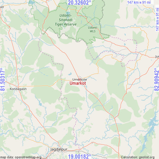
Umarkot GPS coordinates[2]
19° 39' 55.044" North, 82° 12' 22.644" East
| Map corner | latitude | longitude |
|---|---|---|
| Upper-left | 20.32602°, | 81.50317° |
| Center: | 19.66529°, | 82.20629° |
| Lower-right: | 19.00182°, | 82.90942° |
| Map W x H: | 147.2×147.2 km | = 91.5×91.5mi |
| max Lat: | 34.9274° ⇑66.5% North |
| Umarkot: | 19.66529° |
| min Lat: | ⇓33.5% South 8.09008° |
| min Long | Umarkot | max Long |
| 68.82655° | 82.20629° | 96.81° |
| W 77.4%⇐ | ⇒22.6% E |
Elevation
Elevation of Umarkot is 615 m = 2018 ft, and this is 319.4 m = 1048 ft above average elevation for this country.
| Max E: |
3681 m = 12077 ft | 11% |
| Umarkot | 615 m 2018 ft | |
| Avg. | 295.6 m = 970 ft | |
Min E: |
1 m = 3 ft | 89% |
See also: India elevation on elevation.city.
Geographical zone
Umarkot is located in North Torrid zone (between Equator and Tropic of Cancer). Distance of this Northern Tropic circle is 419.3 km =260.5 mi to North.| Distance of | km | miles | from Umarkot |
|---|---|---|---|
| North Pole | 7820.5 | 4859.4 | to North |
| Arctic Circle | 5214.6 | 3240.2 | to North |
| Tropic Cancer | 419.3 | 260.5 | to North |
| Equator | 2186.6 | 1358.7 | to South |


Nearby cities:
15 places around Umarkot: (largest is in red/bold)
• Bhawānipatna
104 km =64.6 mi,  75°
75°
• Gariāband
108.7 km =67.5 mi,  352°
352°
• Gīdam
114.4 km =71.1 mi,  227°
227°
• Jagdalpur
67.8 km =42.1 mi,  196°
196°
• Jeypore
97.8 km =60.8 mi,  156°
156°
• Jūnāgarh
79.1 km =49.2 mi,  74°
74°
• Kantābānji
116.2 km =72.2 mi,  39°
39°
• Kharhiāl
90.3 km =56.1 mi, 39°
• Kondagaon
57.4 km =35.7 mi,  261°
261°
• Korāput
108.6 km =67.5 mi,  150°
150°
• Kotapārh
59.4 km =36.9 mi,  167°
167°
• Kānker
100.6 km =62.5 mi,  312°
312°
• Narharpur
106.5 km =66.2 mi,  324°
324°
• Nowrangapur
60.1 km =37.3 mi,  143°
143°
• Titlāgarh
120.8 km =75.1 mi,  54°
54°
Sources, notices
• [Note1] Compared only with cities in India existing in our database
• [Src1] Map data: © OpenStreetMap contributors (CC-BY-SA)
• [Src2] Other city data from geonames.org with taken over terms of usage.
• [Src3] Geographical zone / Annual Mean Temperature by Robert A. Rohde @ Wikipedia
