Jeypore geodata
Jeypore (Odisha) is a populated place; located in India in Asia/Kolkata (GMT+5.5) time zone. With population of 80,837 people, there are 541 cities with bigger population in this country. Compared to other cities in India, 69.1% of cities are located further ↑North; 78.1% of cities are located further ←West and 88% of cities have lower elevation than Jeypore. Note1


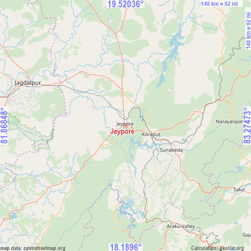
Jeypore GPS coordinates[2]
18° 51' 22.68" North, 82° 34' 17.76" East
| Map corner | latitude | longitude |
|---|---|---|
| Upper-left | 19.52036°, | 81.86848° |
| Center: | 18.8563°, | 82.5716° |
| Lower-right: | 18.1896°, | 83.27473° |
| Map W x H: | 148×148 km | = 92×92mi |
| max Lat: | 34.9274° ⇑69.1% North |
| Jeypore: | 18.8563° |
| min Lat: | ⇓30.9% South 8.09008° |
| min Long | Jeypore | max Long |
| 68.82655° | 82.5716° | 96.81° |
| W 78.1%⇐ | ⇒21.9% E |
Elevation
Elevation of Jeypore is 592 m = 1942 ft, and this is 296.4 m = 972 ft above average elevation for this country.
| Max E: |
3681 m = 12077 ft | 12% |
| Jeypore | 592 m 1942 ft | |
| Avg. | 295.6 m = 970 ft | |
Min E: |
1 m = 3 ft | 88% |
See also: Jeypore elevation on elevation.city.
Geographical zone
Jeypore is located in North Torrid zone (between Equator and Tropic of Cancer). Distance of this Northern Tropic circle is 509.3 km =316.5 mi to North.| Distance of | km | miles | from Jeypore |
|---|---|---|---|
| North Pole | 7910.4 | 4915.3 | to North |
| Arctic Circle | 5304.6 | 3296.1 | to North |
| Tropic Cancer | 509.3 | 316.5 | to North |
| Equator | 2096.6 | 1302.8 | to South |


Nearby cities:
15 places around Jeypore: (largest is in red/bold)
• Balimila
83.2 km =51.7 mi,  216°
216°
• Bobbili
88.7 km =55.1 mi,  110°
110°
• Chittarkonda
94.8 km =58.9 mi,  210°
210°
• Chodavaram
120.5 km =74.9 mi,  161°
161°
• Jagdalpur
63 km =39.1 mi,  293°
293°
• Jūnāgarh
117.9 km =73.3 mi,  18°
18°
• Korāput
15.4 km =9.6 mi, 108°
• Kotapārh
41 km =25.5 mi,  320°
320°
• Malakanagiri
90.5 km =56.2 mi,  232°
232°
• Mādugula
107.7 km =66.9 mi,  166°
166°
• Nowrangapur
41.8 km =26 mi,  356°
356°
• Pārvatipuram
90.2 km =56 mi,  95°
95°
• Sukma
109.2 km =67.9 mi,  241°
241°
• Sālūr
76.7 km =47.7 mi,  119°
119°
• Umarkot
97.8 km =60.8 mi,  336°
336°
Sources, notices
• [Note1] Compared only with cities in India existing in our database
• [Src1] Map data: © OpenStreetMap contributors (CC-BY-SA)
• [Src2] Other city data from geonames.org with taken over terms of usage.
• [Src3] Geographical zone / Annual Mean Temperature by Robert A. Rohde @ Wikipedia
