Kushtagi geodata
Kushtagi (Karnataka) is a populated place; located in India in Asia/Kolkata (GMT+5.5) time zone. With population of 24,180 people, there are 1756 cities with bigger population in this country. Compared to other cities in India, 78.7% of cities are located further ↑North; 71.8% of cities are located further →East and 90.5% of cities have lower elevation than Kushtagi. Note1


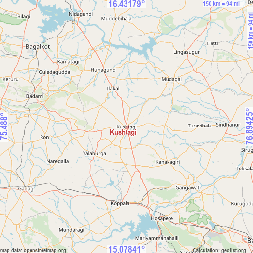
Kushtagi GPS coordinates[2]
15° 45' 22.428" North, 76° 11' 28.032" East
| Map corner | latitude | longitude |
|---|---|---|
| Upper-left | 16.43179°, | 75.488° |
| Center: | 15.75623°, | 76.19112° |
| Lower-right: | 15.07841°, | 76.89425° |
| Map W x H: | 150.5×150.5 km | = 93.5×93.5mi |
| max Lat: | 34.9274° ⇑78.7% North |
| Kushtagi: | 15.75623° |
| min Lat: | ⇓21.3% South 8.09008° |
| min Long | Kushtagi | max Long |
| 68.82655° | 76.19112° | 96.81° |
| W 28.2%⇐ | ⇒71.8% E |
Elevation
Elevation of Kushtagi is 645 m = 2116 ft, and this is 349.4 m = 1146 ft above average elevation for this country.
| Max E: |
3681 m = 12077 ft | 9.5% |
| Kushtagi | 645 m 2116 ft | |
| Avg. | 295.6 m = 970 ft | |
Min E: |
1 m = 3 ft | 90.5% |
See also: India elevation on elevation.city.
Geographical zone
Kushtagi is located in North Torrid zone (between Equator and Tropic of Cancer). Distance of this Northern Tropic circle is 854 km =530.7 mi to North.| Distance of | km | miles | from Kushtagi |
|---|---|---|---|
| North Pole | 8255.1 | 5129.5 | to North |
| Arctic Circle | 5649.2 | 3510.2 | to North |
| Tropic Cancer | 854 | 530.7 | to North |
| Equator | 1751.9 | 1088.6 | to South |


Nearby cities:
15 places around Kushtagi: (largest is in red/bold)
• Bādāmi
57.8 km =35.9 mi,  287°
287°
• Gajendragarh
23.8 km =14.8 mi,  264°
264°
• Gangāwati
51.2 km =31.8 mi,  134°
134°
• Guledagudda
53.9 km =33.5 mi,  307°
307°
• Hampi
55 km =34.2 mi,  148°
148°
• Hospet
58 km =36 mi,  158°
158°
• Hungund
36.8 km =22.9 mi,  337°
337°
• Ilkal
24 km =14.9 mi, 339°
• Koppal
45.9 km =28.5 mi,  184°
184°
• Lingsugūr
57 km =35.4 mi,  38°
38°
• Mudgal
39.1 km =24.3 mi, 43°
• Munirābād
52.1 km =32.4 mi, 162°
• Naregal
45.8 km =28.5 mi,  243°
243°
• Ron
49.3 km =30.6 mi, 262°
• Yelbarga
24.8 km =15.4 mi,  230°
230°
Sources, notices
• [Note1] Compared only with cities in India existing in our database
• [Src1] Map data: © OpenStreetMap contributors (CC-BY-SA)
• [Src2] Other city data from geonames.org with taken over terms of usage.
• [Src3] Geographical zone / Annual Mean Temperature by Robert A. Rohde @ Wikipedia
