Khurda geodata
Khurda (Odisha) is a populated place; located in India in Asia/Kolkata (GMT+5.5) time zone. With population of 42,526 people, there are 1037 cities with bigger population in this country. Compared to other cities in India, 64.6% of cities are located further ↑North; 85.9% of cities are located further ←West and 77.5% of cities have higher elevation than Khurda. Note1


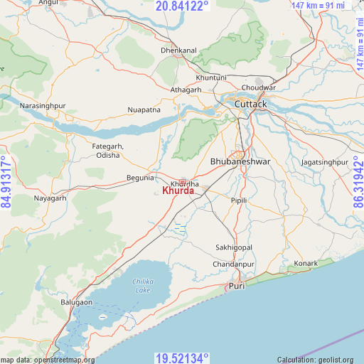
Khurda GPS coordinates[2]
20° 10' 57.648" North, 85° 36' 58.644" East
| Map corner | latitude | longitude |
|---|---|---|
| Upper-left | 20.84122°, | 84.91317° |
| Center: | 20.18268°, | 85.61629° |
| Lower-right: | 19.52134°, | 86.31942° |
| Map W x H: | 146.8×146.8 km | = 91.2×91.2mi |
| max Lat: | 34.9274° ⇑64.6% North |
| Khurda: | 20.18268° |
| min Lat: | ⇓35.4% South 8.09008° |
| min Long | Khurda | max Long |
| 68.82655° | 85.61629° | 96.81° |
| W 85.9%⇐ | ⇒14.1% E |
Elevation
Elevation of Khurda is 57 m = 187 ft, and this is 238.6 m = 783 ft below average elevation for this country.
| Max E: |
3681 m = 12077 ft | 77.5% |
| Avg. | 295.6 m = 970 ft | |
| Khurda | 57 m = 187 ft | |
Min E: |
1 m = 3 ft | 22.5% |
See also: Khurda elevation on elevation.city.
Geographical zone
Khurda is located in North Torrid zone (between Equator and Tropic of Cancer). Distance of this Northern Tropic circle is 361.8 km =224.8 mi to North.| Distance of | km | miles | from Khurda |
|---|---|---|---|
| North Pole | 7763 | 4823.7 | to North |
| Arctic Circle | 5157.1 | 3204.5 | to North |
| Tropic Cancer | 361.8 | 224.8 | to North |
| Equator | 2244.1 | 1394.4 | to South |


Nearby cities:
15 places around Khurda: (largest is in red/bold)
• Bhubaneshwar
24.8 km =15.4 mi,  66°
66°
• Bālugaon
52.5 km =32.6 mi,  269°
269°
• Bānapur
64.7 km =40.2 mi,  226°
226°
• Bānki
23.6 km =14.7 mi,  337°
337°
• Cuttack
41.7 km =25.9 mi,  41°
41°
• Dhenkānāl
52.8 km =32.8 mi,  357°
357°
• Jagatsinghapur
58.5 km =36.4 mi,  82°
82°
• Jatani
9.8 km =6.1 mi,  105°
105°
• Kantilo
48.5 km =30.1 mi,  294°
294°
• Konārka
60.9 km =37.8 mi,  121°
121°
• Nayāgarh
54.6 km =33.9 mi,  263°
263°
• Nimāparha
42.8 km =26.6 mi, 108°
• Pipili
23.7 km =14.7 mi, 108°
• Puri
48 km =29.8 mi,  152°
152°
• Āthagarh
37.5 km =23.3 mi,  2°
2°
Sources, notices
• [Note1] Compared only with cities in India existing in our database
• [Src1] Map data: © OpenStreetMap contributors (CC-BY-SA)
• [Src2] Other city data from geonames.org with taken over terms of usage.
• [Src3] Geographical zone / Annual Mean Temperature by Robert A. Rohde @ Wikipedia
