Kishni geodata
Kishni (Uttar Pradesh) is a populated place; located in India in Asia/Kolkata (GMT+5.5) time zone. With population of 9,852 people, there are 2963 cities with bigger population in this country. Compared to other cities in India, 78.5% of cities are located further ↓South; 61.4% of cities are located further ←West and 58.3% of cities have higher elevation than Kishni. Note1


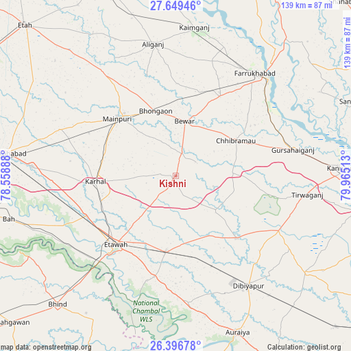
Kishni GPS coordinates[2]
27° 1' 29.532" North, 79° 15' 43.2" East
| Map corner | latitude | longitude |
|---|---|---|
| Upper-left | 27.64946°, | 78.55888° |
| Center: | 27.02487°, | 79.262° |
| Lower-right: | 26.39678°, | 79.96513° |
| Map W x H: | 139.3×139.3 km | = 86.6×86.6mi |
| max Lat: | 34.9274° ⇑21.5% North |
| Kishni: | 27.02487° |
| min Lat: | ⇓78.5% South 8.09008° |
| min Long | Kishni | max Long |
| 68.82655° | 79.262° | 96.81° |
| W 61.4%⇐ | ⇒38.6% E |
Elevation
Elevation of Kishni is 157 m = 515 ft, and this is 138.6 m = 455 ft below average elevation for this country.
| Max E: |
3681 m = 12077 ft | 58.3% |
| Avg. | 295.6 m = 970 ft | |
| Kishni | 157 m = 515 ft | |
Min E: |
1 m = 3 ft | 41.7% |
See also: India elevation on elevation.city.
Geographical zone
Kishni is located in North temperate zone (between Tropic of Cancer and the Arctic Circle). Distance of this Northern Tropic circle is 399 km =247.9 mi to South.| Distance of | km | miles | from Kishni |
|---|---|---|---|
| North Pole | 7002.2 | 4351 | to North |
| Arctic Circle | 4396.3 | 2731.7 | to North |
| Tropic Cancer | 399 | 247.9 | to South |
| Equator | 3004.9 | 1867.2 | to South |


Nearby cities:
15 places around Kishni: (largest is in red/bold)
• Bakewar
41.2 km =25.6 mi,  191°
191°
• Bewar
21.8 km =13.5 mi,  9°
9°
• Bharthana
30.6 km =19 mi, 187°
• Bhongaon
26.8 km =16.7 mi,  342°
342°
• Bidhūna
34.8 km =21.6 mi,  135°
135°
• Chhibrāmau
27.4 km =17 mi,  59°
59°
• Etāwah
36.5 km =22.7 mi,  220°
220°
• Jaswantnagar
39 km =24.2 mi,  246°
246°
• Karhal
32.1 km =19.9 mi,  265°
265°
• Mainpuri
32.3 km =20.1 mi,  314°
314°
• Muhammadābād
35.8 km =22.2 mi,  28°
28°
• Nagla Panchi
17.1 km =10.6 mi, 305°
• Sarai Ekdil
35.4 km =22 mi,  208°
208°
• Saurikh
22.4 km =13.9 mi,  88°
88°
• Tālgrām
38.3 km =23.8 mi, 86°
Sources, notices
• [Note1] Compared only with cities in India existing in our database
• [Src1] Map data: © OpenStreetMap contributors (CC-BY-SA)
• [Src2] Other city data from geonames.org with taken over terms of usage.
• [Src3] Geographical zone / Annual Mean Temperature by Robert A. Rohde @ Wikipedia
