Nagla Panchi geodata
Nagla Panchi (Uttar Pradesh) is a populated place; located in India in Asia/Kolkata (GMT+5.5) time zone. With population of 1,000 people, there are 3463 cities with bigger population in this country. Compared to other cities in India, 79.3% of cities are located further ↓South; 60.1% of cities are located further ←West and 58.3% of cities have higher elevation than Nagla Panchi. Note1


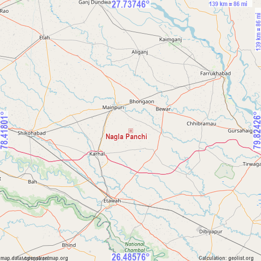
Nagla Panchi GPS coordinates[2]
27° 6' 48.096" North, 79° 7' 16.068" East
| Map corner | latitude | longitude |
|---|---|---|
| Upper-left | 27.73746°, | 78.41801° |
| Center: | 27.11336°, | 79.12113° |
| Lower-right: | 26.48576°, | 79.82426° |
| Map W x H: | 139.2×139.2 km | = 86.5×86.5mi |
| max Lat: | 34.9274° ⇑20.7% North |
| Nagla Panchi: | 27.11336° |
| min Lat: | ⇓79.3% South 8.09008° |
| min Long | Nagla Panchi | max Long |
| 68.82655° | 79.12113° | 96.81° |
| W 60.1%⇐ | ⇒39.9% E |
Elevation
Elevation of Nagla Panchi is 157 m = 515 ft, and this is 138.6 m = 455 ft below average elevation for this country.
| Max E: |
3681 m = 12077 ft | 58.3% |
| Avg. | 295.6 m = 970 ft | |
| Nagla Panchi | 157 m = 515 ft | |
Min E: |
1 m = 3 ft | 41.7% |
See also: India elevation on elevation.city.
Geographical zone
Nagla Panchi is located in North temperate zone (between Tropic of Cancer and the Arctic Circle). Distance of this Northern Tropic circle is 408.8 km =254 mi to South.| Distance of | km | miles | from Nagla Panchi |
|---|---|---|---|
| North Pole | 6992.3 | 4344.8 | to North |
| Arctic Circle | 4386.5 | 2725.6 | to North |
| Tropic Cancer | 408.8 | 254 | to South |
| Equator | 3014.7 | 1873.2 | to South |


Nearby cities:
15 places around Nagla Panchi: (largest is in red/bold)
• Alīganj
42.6 km =26.5 mi,  6°
6°
• Bewar
21 km =13 mi,  56°
56°
• Bharthana
41.4 km =25.7 mi,  166°
166°
• Bhongaon
16.8 km =10.4 mi,  20°
20°
• Chhibrāmau
37.8 km =23.5 mi,  84°
84°
• Etāwah
38.8 km =24.1 mi,  194°
194°
• Ghiror
33.5 km =20.8 mi,  284°
284°
• Jaswantnagar
33.6 km =20.9 mi,  220°
220°
• Karhal
21.9 km =13.6 mi,  235°
235°
• Kishni
17.1 km =10.6 mi,  125°
125°
• Mainpuri
15.7 km =9.8 mi,  324°
324°
• Muhammadābād
37.7 km =23.4 mi,  54°
54°
• Sarai Ekdil
41.1 km =25.5 mi,  183°
183°
• Saurikh
37.5 km =23.3 mi,  104°
104°
• Sirsāganj
43.5 km =27 mi,  261°
261°
Sources, notices
• [Note1] Compared only with cities in India existing in our database
• [Src1] Map data: © OpenStreetMap contributors (CC-BY-SA)
• [Src2] Other city data from geonames.org with taken over terms of usage.
• [Src3] Geographical zone / Annual Mean Temperature by Robert A. Rohde @ Wikipedia
